

Posted by Jody Peters with input from Simon Goring and Chris Paciorek
Just as many trees make up a mighty forest, many participants are needed to pull together and analyze data for PalEON. Together we gain a deeper understanding of past forest dynamics, and use this knowledge to improve long-term forecasting capabilities. Major components needed to understand past forest dynamics are tree composition, density and biomass prior to Euro-American settlement. In true macrosystems ecology fashion, over the past 3 years (and in some cases longer) individuals from multiple institutions (see Table and Figure captions, and Figure 3 here) have been working on collecting the data and developing a statistical multinomial model for tree composition in the Northeast and Midwest United States. Our first task has been to estimate percent composition for several of the dominant forest taxa, and to provide reliable estimates of uncertainty.
We are excited to announce we have finally collected enough data to run the model across the entire northeastern United States! Figure 1 provides an example of the composition results and associated uncertainty for beech and pine. In addition to these two genera we have similar results for taxa such as oak, birch, hickory, maple, spruce, etc. We can use these results to compare the pre-European Settlement forest composition to modern forests from US Forest Service Forest Inventory Assessment data as well as those extending 2000 years into the past using pollen data and STEPPS2 analyses (see this University of Wisconsin Press Release). As we move forward with this project we will continue to update our datasets that have dispersed sampling (e.g., Indiana, Illinois and Ohio: Table 1) and we are in the process of developing maps of estimated density and biomass by tree taxon.
Stay tuned as more results come in and as the manuscripts get published!
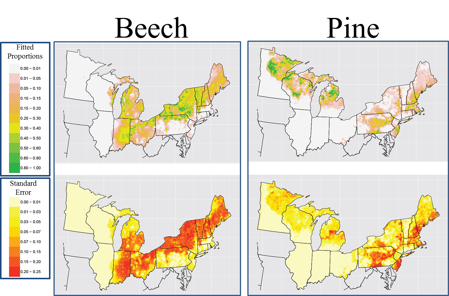
Figure 1. Estimated composition (top maps) and associated uncertainty (bottom maps) created March 2014. Estimates come from a spatial multinomial model on an 8 km Albers grid, developed by Andy Thurman from the University of Iowa and Chris Paciorek and Andria Dawson from the University of California, Berkeley. The MCMC was run for 150,000 iterations, with the first 25,000 discarded as burn-in, and the remaining iterations subsampled (to save on storage and computation) to give 500 posterior draws.
Click on the image for a bigger, clearer picture.
Table 1. Source of tree data from Public Land Surveys from locations in the Northeast and Midwest United States. The “Sampling” column indicates when data came from the entire location (complete) or from a dispersed sample of townships or towns within the location.
| Location | Sampling | Source |
|---|---|---|
| Minnesota | Complete | David Mladenoff(University of Wisconsin - Madison) |
| Wisconsin | Complete | David Mladenoff(University of Wisconsin - Madison) |
| Michigan's Upper Peninsula & northern Lower Peninsula | Complete | Michigan Department of Natural Resources; David Mladenoff |
| Michigan's southern Lower Peninsula | Dispersed | Jack Williams & Simon Goring (University of Wisconsin - Madison) |
| Illinois | Dispersed | Jason McLachlan (University of Notre Dame) |
| Illinois Chicago area | Complete | Marlin Bowles & Jenny McBride (The Morton Arboretum) |
| Illinois St. Louis area | Complete | Dick Brugam (Southern Illinois University) & Paul Kilburn (Jefferson County Nature Association) |
| Indiana | Dispersed | Jason McLachlan (University of Notre Dame) |
| Ohio | Dispersed | Charles Cogbill |
| New England, New Jersey, New York and Pennsylvania | Dispersed | Charles Cogbill |