

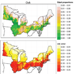
Settlement Vegetation Composition Maps
This product is the estimated composition at the resolution of the PalEON 8 km Albers grid, estimated with a Bayesian spatial multinomial model, developed by Andy Thurman and Chris Paciorek and fit using Markov chain Monte Carlo (MCMC). The MCMC was run for 150,000 iterations, with the first 25,000 discarded as burn-in, and the remaining iterations subsampled (to save on storage and computation) to give 250 posterior draws. All plots and data are for the full domain (Midwest plus East subdomains).
Version 0.4 results, August 2015
Details about the model can be found in our 2016 PLOS One paper.
To see all plots in static or dynamic views go to:
| Static Maps | Dynamic Maps |
|---|---|
 |  |
Data is available to download in the Dynamic View.