2. Juday Creek, IN
Apr 8th, 2014 by Kristin Lewis
Juday Creek is home to reproducing trout populations and we will occasionally see large trout running upstream during the spring. If you encounter such a fish, please admire it quietly from a distance.
The location were we are sampling is just upstream from where the stream empties into the St. Joseph River, which then runs north and empties into Lake Michigan. The northern section of South Bend (including Notre Dame) is part of the St. Joseph River Basin, while the southern portion of South Bend (like near the original Bruno’s on Prairie Ave.) is part of the Kankakee River Basin and empties into the Mississippi River and the Gulf of Mexico.
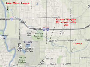
The U.S. Geological Survey (USGS) maintains a gauging station on Juday Creek in Izaac Walton League. This gauging station measures the height of water in the stream and estimates the discharge rate (cubic feet per second) of water moving through that point of the stream.
You can check current conditions at Juday Creek here:
Juday Creek Flow Rate and Discharge Gauge
Concept Check Question (answer on Sakai):
Which of the following statements about Juday Creek is FALSE?
A. The majority of Juday Creek is surrounded by natural woodlands.
B. Water from the stream eventually empties into the Lake Michigan.
C. Juday Creek contains reproducing trout populations.
D. Juday Creek contains a USGS gauging station that tracks water height and discharge.