

Post by Bryan Shuman, Associate Professor of Geology & Geophysics at the University of Wyoming
To evaluate how forests have responded to climate change in the past, we need to reconstruct the climate history. Fortunately, in terms of moisture, lakes provide a geological gauge of precipitation (P) minus evapotranspiration (ET). As effective moisture (P-ET) changes, the water tables and lake surfaces rise and fall in elevation. When this happens, sands and other materials that typically accumulate near the shore of a lake are either moved deeper into the lake during low water or shift out from the lake’s center as water levels rise. Ongoing work in New England is building on existing datasets to provide a detailed picture of the multi-century trends in effective moisture. Here are a few highlights of recent progress.
First “the fun part” was fieldwork that I conducted while on sabbatical in New England. The work included a cold but fun day on the ice of Twin Pond in central Vermont with Laurie Grigg and students from Norwich University (pictured).

Coring at Twin Ponds
This trip was a follow up to a previous trip that coincided with Hurricane Sandy’s visit to New England in 2012. As the result of both trips, we now have a series of three cores that record shoreline fluctuations at the pond. Because the sediment contains both carbonate minerals and organic compounds, we have also been able to examine the ratios of oxygen and hydrogen isotopes in the sediment and provide some constraints on the temperature history too.
Ice makes coring easy (its stable), but the swimming was not as good as in the summer when I worked in southern New England with Wyatt Oswald (Emerson College), Elaine Doughty (Harvard Forest), and one of Harvard Forest’s REU students, Maria Orbay-Cerrato. Over several days, we collected new cores that record the Holocene water-level changes at West Side Pond in Goshen, Connecticut, and Green Pond, near Montague, Massachusetts. Floating on a pair of canoes, we enjoyed the early summer sun, told jokes, ate delightful snacks brought from home by Wyatt, and strained our muscles to pull about 5 cores out of each lake. Near shore, the cores from both lakes contained alternating layers of sand and mud consistent with fluctuating water levels. In the lake center at West Side Pond, we also obtained two overlapping cores about 14 m long, which promise to provide a detailed pollen record. Both lakes proved to be excellent swimming holes too!
Second, on a more earnest note, the existing geological records of lake-level change from Massachusetts have been synthesized in a recent (2014) paper in Geophysical Research Letters by Paige Newby et al. The figure shown here summarizes the results and compares the reconstructions with the pollen-inferred deviation from modern annual precipitation levels from a paper by University of Wyoming graduate student, Jeremiah Marsicek, last year (2013) in Quaternary Science Reviews.
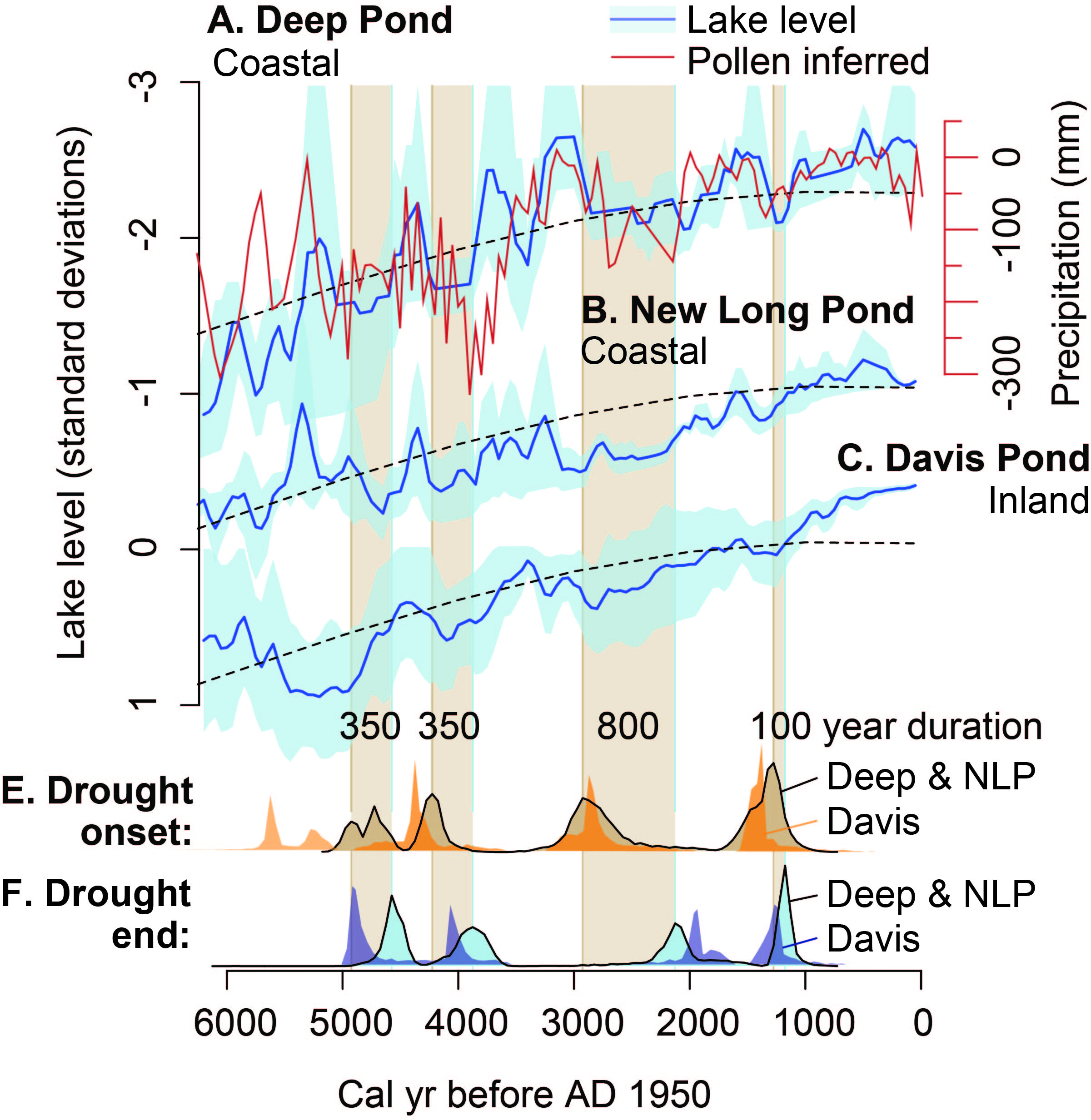
Figure 4 from Newby et al. 2014
All of the records show a long-term rise in effective moisture since >7000 years ago as well as meaningful multi-century deviations. By accounting for the age uncertainties from the reconstructions, we were able to show that a series of 100-800 year long droughts at 4200-3900, 2900-2100, and 1300-1200 years before AD 1950 affected lake levels (blue curves with reconstruction uncertainty shown) on Cape Cod (Deep Pond), the coastal Plymouth area (New Long Pond), and the inland Berkshire Hills (Davis Pond) – as well as the forest composition as recorded by the pollen from Deep Pond (red line). Interestingly, an earlier drought in the Berkshires at 5700-4900 years ago was out of phase with high water recorded in the eastern lakes. This difference is one of the motivations for the new work in Vermont, Connecticut and central Massachusetts, as well as other ongoing work with Connor Nolan in central Maine: what are the spatial patterns of drought?