PalEON at ESA and CANQUA/AMQUA 2018

Next week is big for us! We have lots o PalEON work to check out at CANQUA/AMQUA and ESA.  

CANQUA/AMQUA Presentations

PresenterDateTimeLocationTitle
Connor NolanSaturday, August 119:20 AMRoom BA new multiarchive record of Holocene vegetation and climate in Maine: droughts, declines, and disturbances
Andria DawsonSaturday, August 1111:20 AMRoom BReconstructing land cover: a spatio-temporal approach to estimate past forest composition from fossil pollen records

ESA Presentations

PresenterDateTimeLocationTitle
Neil PedersonMonday, August 62:10 PM346-347Strange days and their changeling legacies in the life of trees in temperate mesic forests 
Jason McLachlanMonday, August 63:30 PM244Why we need statistical models of  paleodata  to predict the future
Mathias TrachselTuesday, August 78:20 AMESA Exhibit Hall; Poster 15-51Reconstructing settlement-era forest composition for the northeastern US: A comparison of pollen vegetation models STEPPS and LOVE/REVEALS
Bethany BlakelyWednesday, August 810:50 AM333-334 Forest transition reduces surface temperature by altering biophysical properties in second-growth canopies 
Kelly HeilmanWednesday, August 810:10 AM348-349Tree growth in a changing world: Factors mediating the effects of CO2 on tree ring growth and Water Use Efficiency 
Christy RollinsonThursday, August 92:30 PM333-334Connecting pattern and process: Climate-driven shifts in composition facilitate biomass stability over the past millennium 
Kevin BurkeThursday, August 93:40 PM333-334A comparison of climatic mechanisms and plant community novelty in North America and Europe from the last glacial maximum to present

10th World Dendro Conference Re-cap

Post by Ann Raiho, Kelly Heilman, and Andria Dawson. This post is cross-listed on the McLachlan lab website.

The 10th World Dendro Conference was held in Bhutan this summer! A Dendro Fieldweek was held the week prior to the conference where individuals learned about dendrochronology and reconstructing climate from tree rings, forest ecology and forest dynamics.  PalEON had 4 participants including two grad students from the McLachlan lab.  Below are the impressions and experiences from McLachlan members, Ann Raiho and Kelly Heilman and PalEONista, Andria Dawson.

Ann’s Impressions
Bhutan was an excellent destination for World Dendro for many reasons, mainly the country’s unique perspective on forest conservation. Bhutan is the only country in the world that could be considered carbon neutral or even carbon negative because of the amount of forest that the country preserves. Over 70% of Bhutan is forested and will remain so for the foreseeable future. The fourth king set in place a mandate that the country should always remain 70% forests. So many trees! Furthermore, Ed Cook and Paul Krusic have been working in Bhutan for over 25 years and have helped the Bhutanese establish a proliferate tree-ring lab that has been in operation since 2001.

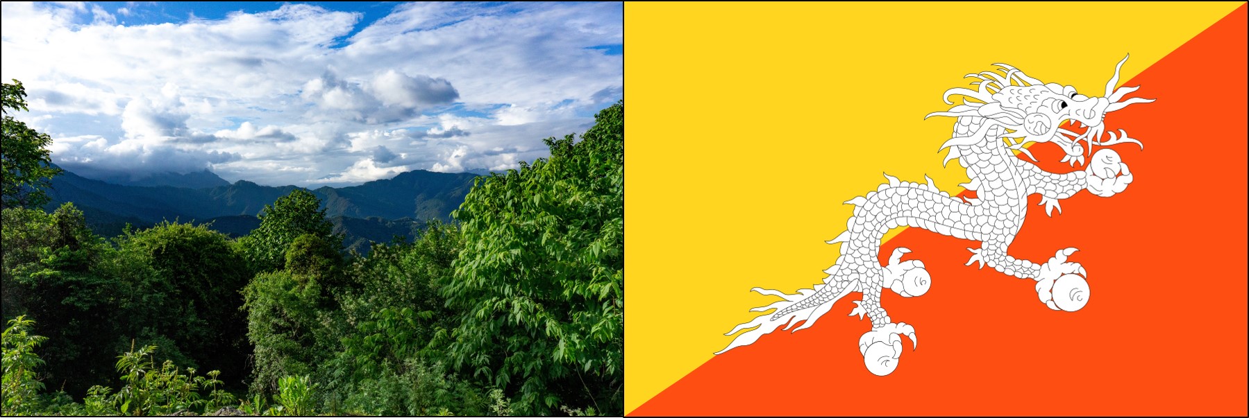
Bhutan is known as the Land of the Thunder Dragon. The Bhutan flag (right) shows an image of Druk, the Thunder Dragon

I attended the Dendro Fieldweek. Around 30 international students and 20 Bhutanese students traveled 14 hours by bus to Bhumthang, Bhutan where there is a field station located next to the first queen’s palace.

Views from the Bus

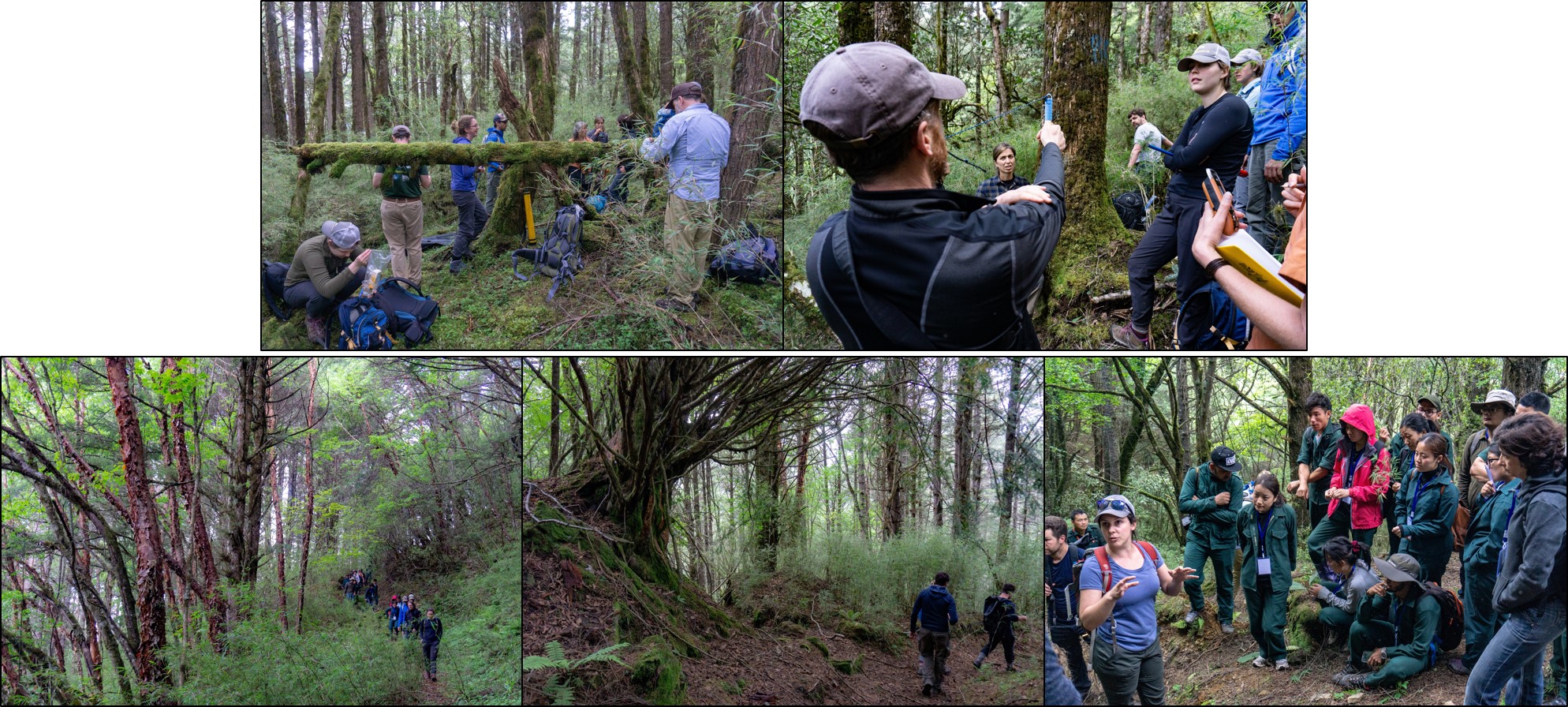
The field week consisted of field work, tree ring analysis, and presentations of findings. There were groups working on dendroecology, dendrohydrology, and blue light intensity measurements. The dendroecology group was led by PalEONista, Neil Pederson!

Mounting and Measuring Tree Cores

Tree Cookies

We explored the relationship between fir and hemlock along an elevational gradient and found that fir growth may be more sensitive to increasing temperature. At the end of the week everyone presented in their groups, my group’s presentation was about dendroecology and how you can incorporate disturbance history and biomass estimates to tell a story about the forest’s development.  I snuck some LINKAGES (forest gap model) runs in to show how ecosystem models can be used in conjunction with tree ring data to learn about limiting resources over successional time scales. Our final night at the field station was spent dancing around a bonfire in traditional Bhutanese fashion (pinky’s locked together to form a circle) and singing karaoke.

Exploring the Forests of Bhutan

Kelly’s Impressions
A traditional Marchang ceremony opened the conference and kicked off a fun dendro-filled week.The first section of talks discussed fusing both forest inventory analyses and dendrochronology methods and included awesome talks from two of our own PalEON members (Ann and Andria Dawson). Throughout the week, I learned about researchers around the world using dendrochronology to reconstruct volcanic events, to explore past human-environment interactions, and to better understand the impacts of earthquakes of forest disturbances. My favorite section was the encouragingly large dendroecology section (I’m biased), which discussed quantifying forest disturbances, the impacts of management and land-use on tree growth, and ultimately exploring how ecological variation might affect growth-climate relationships. I gave a talk in this section titled “Anthropogenic changes impact drought sensitivity across a savanna-forest biome boundary,” which highlighted results showing that both stand structure changes and increases in CO2boundary can impact drought sensitivity at the savanna-forest boundary.

To wrap up the conference, Soumaya Belmecheri gave a stellar Florence Hawley Diversity Lecture that blended both her research reconciling the differences observed between tree ring data and Eddy Flux data and an eloquent call for supporting greater diversity in dendrochronology. In between our packed conference schedule and before leaving Bhutan, we squeezed in some culture and exploration. My favorites were the traditional dancing at the conference banquet, venturing up to the massive Buddha, trekking up to Taktsang Buddhist monastery (aka “Tiger’s Nest”) with Andria, and eating all the spicy ema datshi and momos possible!

Some short hikes brought us to amazing views! Left: views from the large Buddha temple in Thimphu. Middle: Buddha Dordenma statue. Right: A large prayer wheel on the way up to Taktsang monastery near Paro. Look closely at the prayer wheel and you’ll see one of the friendly dogs that accompanied us on our hikes and always found the best napping places!

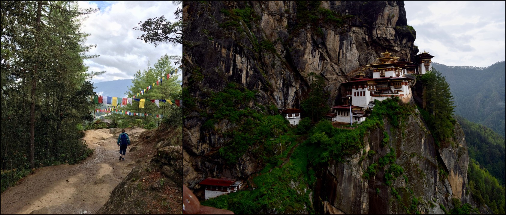
Hiking to Taktsang Monastery (Tiger’s Nest) with Andria. Taktsang monastery is located on a cliffside around 10,000 ft elevation. We enjoyed the pine forests, prayer flags, and views of the valley on the way up!

Andria’s Impressions
Bhutan has undergone a wave of modernization over the last 40 years. They are now at a point in time where they have the infrastructure to conduct and disseminate scientific research. Ed and Paul have been working in collaboration with Bhutanese colleagues for some time; however, there is still a lot to learn about the forests of Bhutan (and how they fit into our global perspective of the biosphere). Our Bhutanese colleagues at the conferences continued to emphasize their commitment to collaboration with international colleagues.

I want to thank the people of the Kingdom of Bhutan for welcoming us. Their generosity and profound appreciation for the environment and all living things has had a profound impact on my perspective of life and humanity. Bhutan, you are far away (from North America) but never forgotten.

Left: PalEON Pals, Middle: Traditional Dancers at the Closing Banquet. We all joined later!, Right: A Good Reminder To Go Home With

PalEON at the 2017 Ecological Society of America Meeting

Going to Portland this year?  Check out the PalEONistas who are presenting this year!

PalEON PresenterDateTimeSessionTitle
Simon Goring (session organizer)Monday, August 710:15am-11:30amSS 7Standing on the Shoulders of Clients: Evolving Cyberinfrastructure in the Ecological Sciences
Megan SeeleyTuesday, August 84:30pmPS 26-137Environmental and historical controls on  Fagus grandifolia  settlement-era distributions in the upper Midwest 
Jack WilliamsTuesday, August 84:20pmOOS 14-9Macroecological insights from community-curated data repositories (CCDRs) of paleoecological sites: Neotoma and PalEON
Bethany BlakelyWednesday, August 910:50amCOS 77-9Historic land use increases transpiration and reduces canopy surface temperature through persistent changes in forest composition and structure
Simon GoringWednesday, August 92:50pmCOS 104-5The neotoma database: Recent developments and future directions
Andria DawsonWednesday, August 93:40pmCOS 105-7Estimating changes in prehistoric forest composition from sediment pollen in the Upper Midwestern United States
Kelly HeilmanThursday, August 1010:30amCOS 132-8Stabilization of savanna-forest alternative states to closed forests after ~150 years of land use and climate changes
Christy RollinsonThursday, August 104:00pmCOS 158-8Forest ecosystem stability in a millennium of climate change in terrestrial ecosystem models
Istem FerFriday, August 119:00amOOS 50-4Hierarchical Bayesian calibration of a dynamic vegetation model
Ann RaihoFriday, August 119:20amOOS 50-5Assimilating tree ring and fossil pollen data to improve understanding of unobservable forest processes
Dave MooreFriday, August 119:50amOOS 50-6Combining models and data to understand vegetation function across timescales
Malcolm ItterFriday, August 1110:50amOOS 50-9Assimilation of tree-ring and repeat census data to model interactions between climate and past forest dynamics

Oak Trees and Climate in the Midwest

Post by Kelly Heilman, a graduate student with Jason McLachlan at the University of Notre Dame

If trees could talk…

Every year, oak trees in the Midwest awaken in spring, to spread their leaves to grow through the summer, and settle down for a long winter’s rest in the fall. As we watch this seasonal cycle, trees warn us of the coming of winter as they shed their leaves, putting on a glorious show of red, gold and orange. At times, trees tell us to slow down by inviting us into their expansive shade to rest, read a book, and listen the birds sing in the distance. However, to many dendrochronologists, trees talk about something else–their records of the past. The patterns of each season’s tree growth are recorded in the annual rings of trees, and are protected like a memory beneath the tree’s bark. These annual variations in tree rings provide researchers with information on the responses of trees to climate variations, as well as to other stresses that trees face, such as competition with their neighbors for light, and fire disturbances. All this makes tree ring records particularly useful tools for looking into the past. So, in a way trees can talk . . . but it takes some effort for us to listen to them.

Trees in the temperate zone, such as this Bur Oak, record annual rings of growth, allowing us to count their rings to get tree age, and correlate growth with climate records. Pictured above is a 5-mm wide core sample from a tree at Bonanza prairie SNA (Scientific and Natural Area) in Minnesota, with the bark pictured on the left and the center of the tree on the right. (Click on image for a larger view.)

Looking at the past responses of ecosystems to climate variations through the lens of tree rings can provide a better understanding of how these ecosystems might respond to future changes. My research focuses broadly on the savanna-forest boundary in the Midwest, both on the environmental conditions that form this boundary and how environmental changes impact these savannas and forests. Over the last century, humans have altered the landscape in the Midwest, through large scale agriculture, land-use change, fire suppression, changes in CO2 and climate shifts (Goring et al. 2016, Rhemtulla et al. 2007). Many of these changes have likely affected the growth, survival, and climate sensitivity of trees, which could impact the trajectory of forests in the future. Therefore, I set out to quantify how savanna and forest trees functioned both in the past, and on the modern landscape. Using annual growth increments recorded in tree rings, my objective was to quantify how both modern and past ecosystems functioned (in terms of how much carbon they uptake and store in their annual growth rings), and to determine if and how tree growth patterns vary across temperature, precipitation, and soil gradients.

Thoughts from the field (don’t forget your bug spray and sunscreen):

To view the annual rings of tree growth, we collected tree core samples from sites across the historic savanna-forest boundary in the Midwest from several Minnesota Scientific and Natural Areas (SNAs), Minnesota State Parks, State Parks in Iowa and Missouri, as well as several sites within McHenry County Conservation District in Illinois (see map). In my sampling design, I aimed to capture the growth responses of young and old trees in both savannas and forests, across the wet-to-dry climate gradient in the Midwest. We targeted several Oak species, including Bur Oak (Quercus macrocarpa), White Oak (Quercus alba), Red Oak (Quercus rubra), and Chinkapin Oak (Quercus muehlenbergii), but also sampled several eastern forest species as well. With the help of fellow Paleonistas (Ann Raiho, Monika Shea) and field technicians Evan Welsh and Santi Thompson, we sampled tree cores at 23 different sites during the summers of 2015 and 2016. Coring trees can be monotonous, physically difficult, and relaxing all at the same time. Lucky for us, we got to go to some beautiful places across the Midwest.
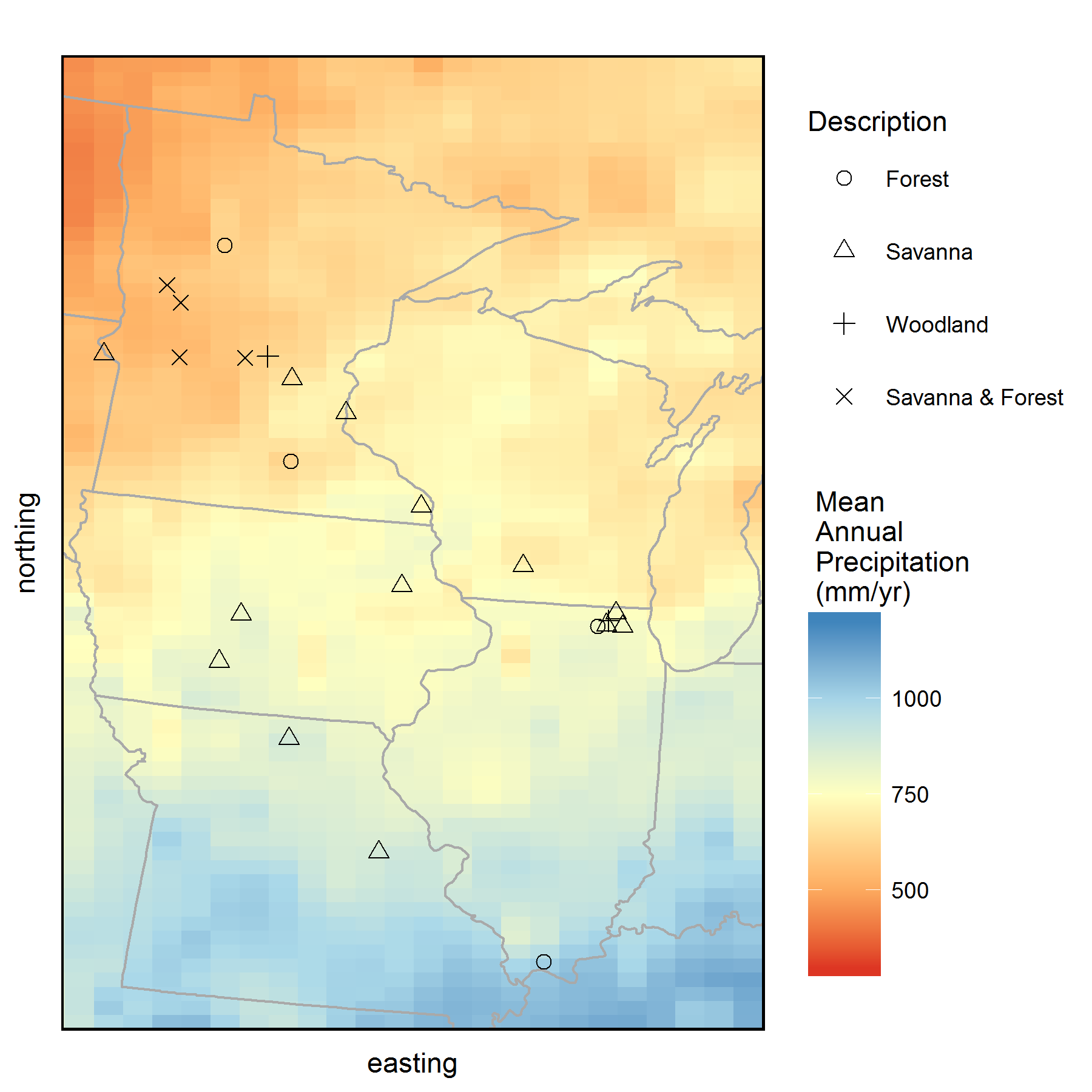
Map of all the sites where we collected tree core samples from during 2015 and 2016. Background color represents mean annual precipitation (MAP) of the region obtained from PRISM climate data. Tree cores were collected from savannas and forests that occur along the historic prairie-forest boundary in the Midwest. (Click on image for a larger view.)
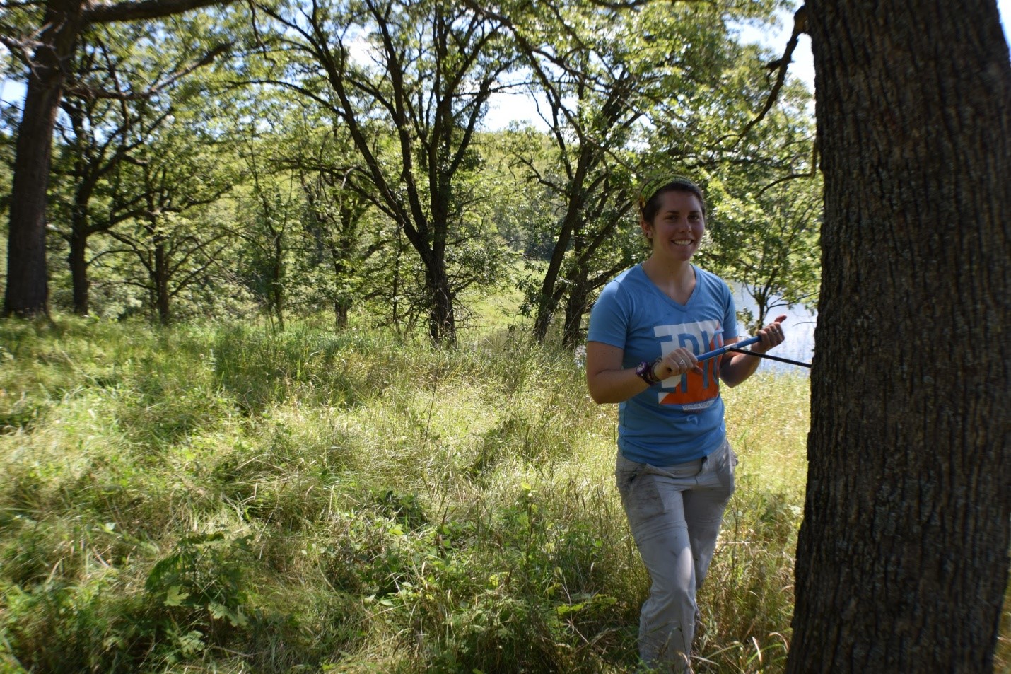
Coring a large Bur Oak tree in a savanna at Maplewood State Park, Minnesota.
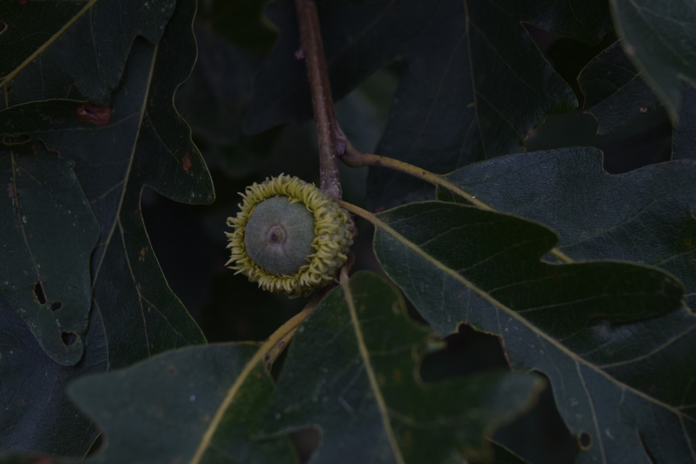
Bur Oak acorn from a young tree located in St. Croix savanna SNA in Minnesota
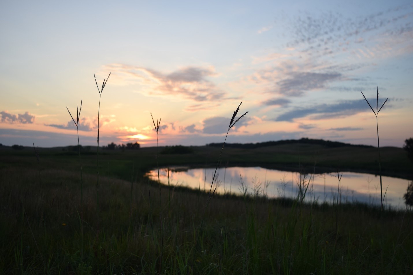
Working out in the field gave us opportunities to see some awesome ecosystems and sunsets. Looking out onto to prairie from a savanna at Glacial Lakes State Park, MN, the tallest plants were not trees, but tallgrass prairie plants, such as the Big Bluestem, or “turkey foot” (Andropodon gerardii) pictured here.
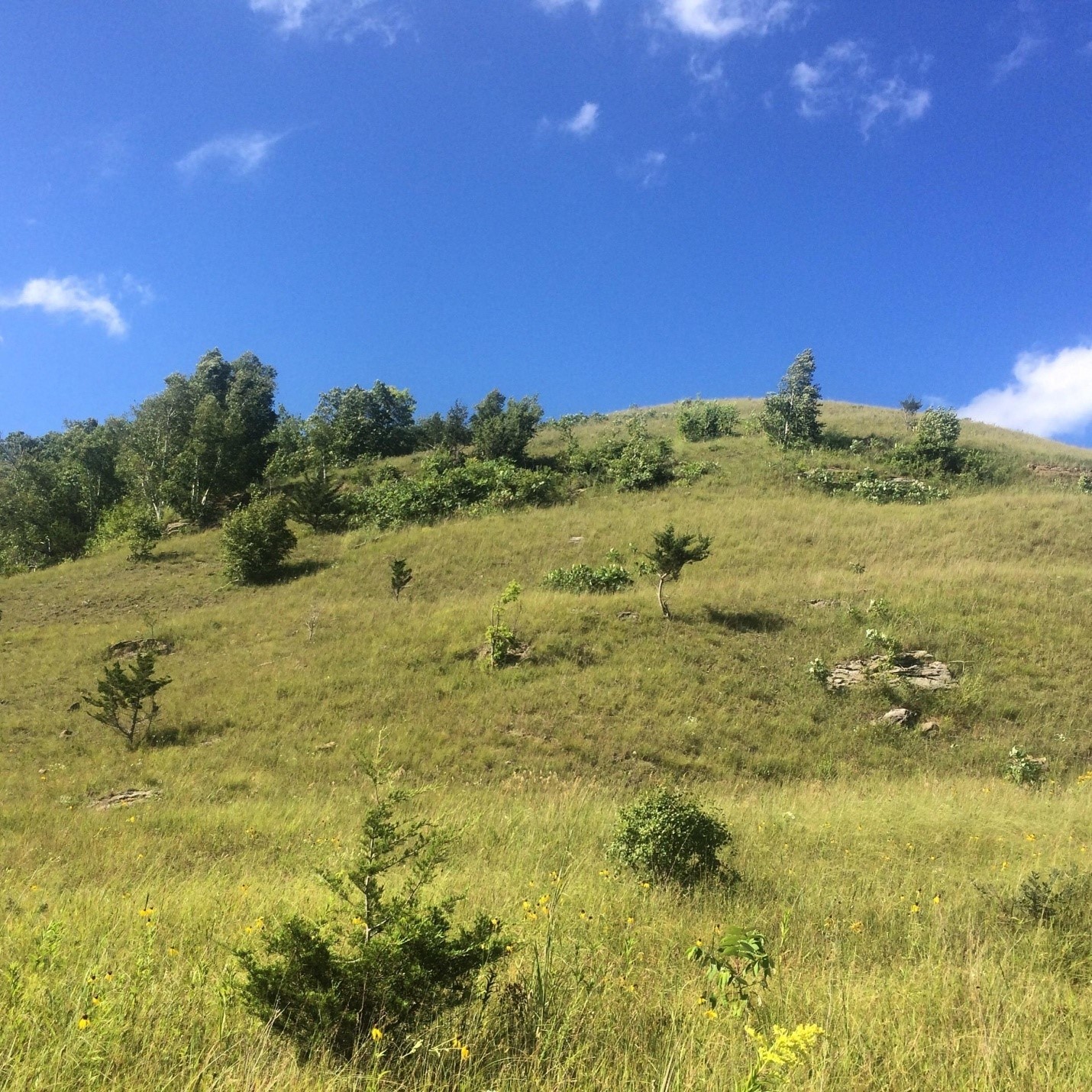
An open savanna and prairie complex at Mound Prairie SNA, in Minnesota.
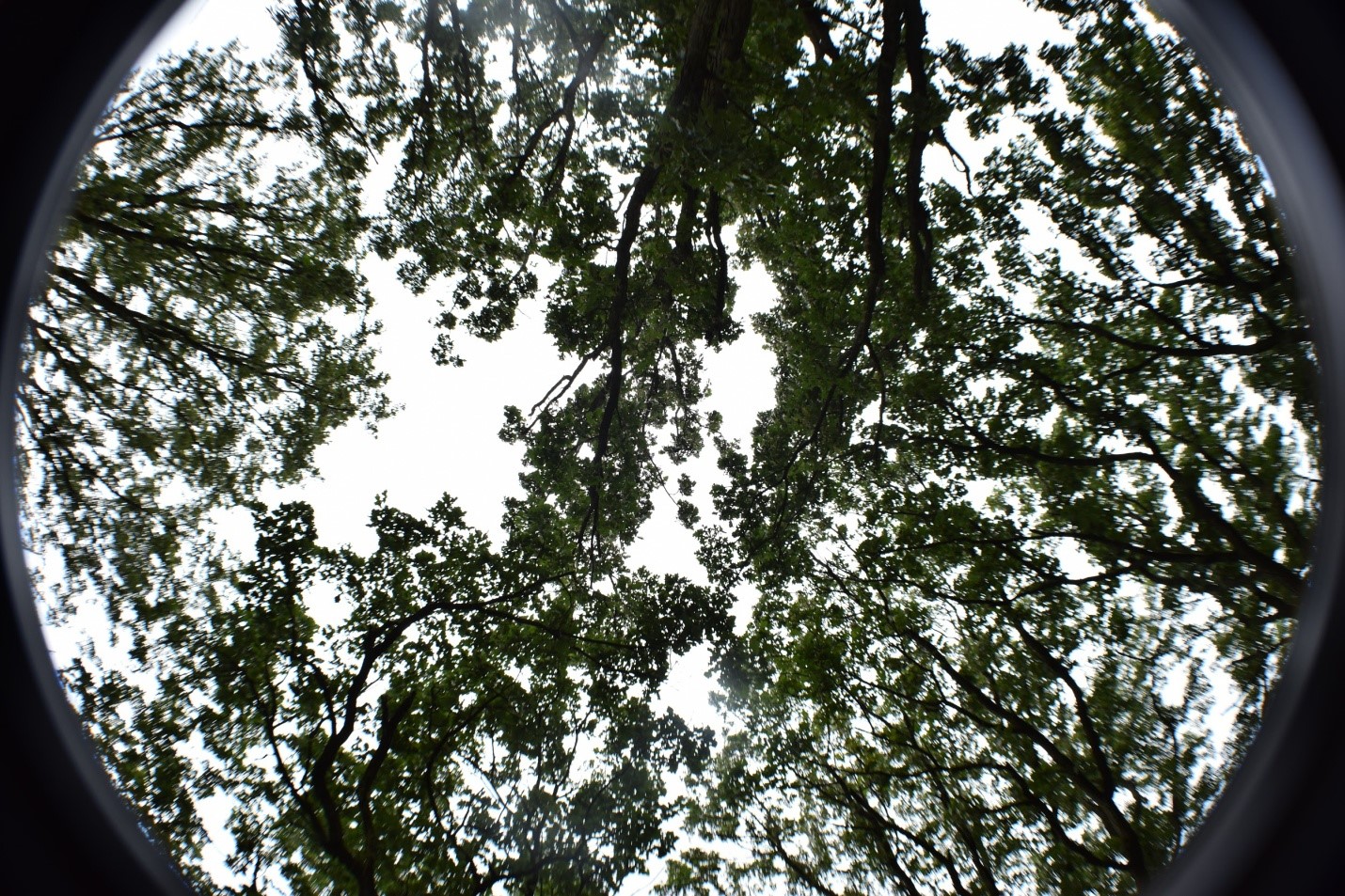
The Oak savanna canopy is sparse compared to a closed forest, letting in plenty of light for understory grasses and forbs to grow.

After driving a couple thousand miles total, spending over 30 nights in a tent in 2015 and 2016, and battling what seemed like an infinite amount of mosquitoes and ticks, we headed back to the lab to measure the width of each annual tree ring, and determine how climate affects Midwestern oak tree growth.

Back at the Lab:

Once we returned from the field, the cores were glued to wooden mounts, sanded, counted and measured. This work was done with the help of several awesome undergraduate students over the last two years, including: Jacklyn Cooney, Clare Buntrock, Santi Thompson, and Da Som Kim. Once the cores were measured and cross-dated with each other (using common “marker” years of extremely low growth, such as the 1934 Dust bowl drought, to double check our measurements), we have a temporal record of growth fluctuations for each site.

What climate factor affects oak tree growth in savannas and forests?

Tree growth responds strongly to the most limiting factor to their growth.

For example, in water limited regions of Southwestern North America, tree growth is highly correlated with interannual precipitation and drought, often making tree ring records from these regions good candidates for precipitation reconstructions (Charney et al. 2016, Peterson 2014). However, in many Eastern North American forests, water availability for growth is not a huge limiting factor, and tree growth is more sensitive to summer temperatures, drought, and light availability (Peterson 2014, Charney et al. 2016).  The savanna-forest boundary in the Midwest is located between these Eastern closed forests and the more water limited prairies to the West. Therefore, tree species that occur along this boundary are often thought to exist at the edge of their theoretical and climatic range boundaries, and theoretically could respond strongly to moisture stress or temperature stress. The historic transition from open prairie to savanna to forests occurred at a range of precipitation and temperature climatic envelopes; this transition zone in Minnesota had low mean annual precipitation (300-600 mm/year), and much higher mean annual precipitation in Indiana & Illinois (700-1200). Therefore, I originally hypothesized that these western savannas and forests may respond more strongly to low precipitation and drought than Eastern savannas and forests.

Contrary to my original hypotheses, oak tree ring growth is not primarily controlled by precipitation in oak trees near the savanna-forest boundary. Rather, tree growth at most sites is strongly linked to summer drought severity and summer temperatures. The negative impacts of drought on tree ring growth are likely mediated by temperature-induced drought stress, as suggested by the strong negative correlations with minimum and maximum June and July temperatures at almost all sites. While growth at some sites is mildly correlated to late summer precipitation, these places tend to have sandy soils, suggesting that future decreases in precipitation could have larger negative consequences for tree growth on sites with sandy soils. Interestingly, despite low moisture availability, sites with the lowest mean annual rainfall were only weakly correlated with monthly precipitation, suggesting that perhaps these systems are relying heavily on deeper groundwater sources for water. However, sites with low rainfall, such as Bonanza Prairie SNA in Minnesota, do have strong sensitivity to drought indices (Palmer Drought Severity Index, PDSI) and temperature indicating that high temperature drought stress, rather than water stress due to low precipitation is more important in this ecosystem.
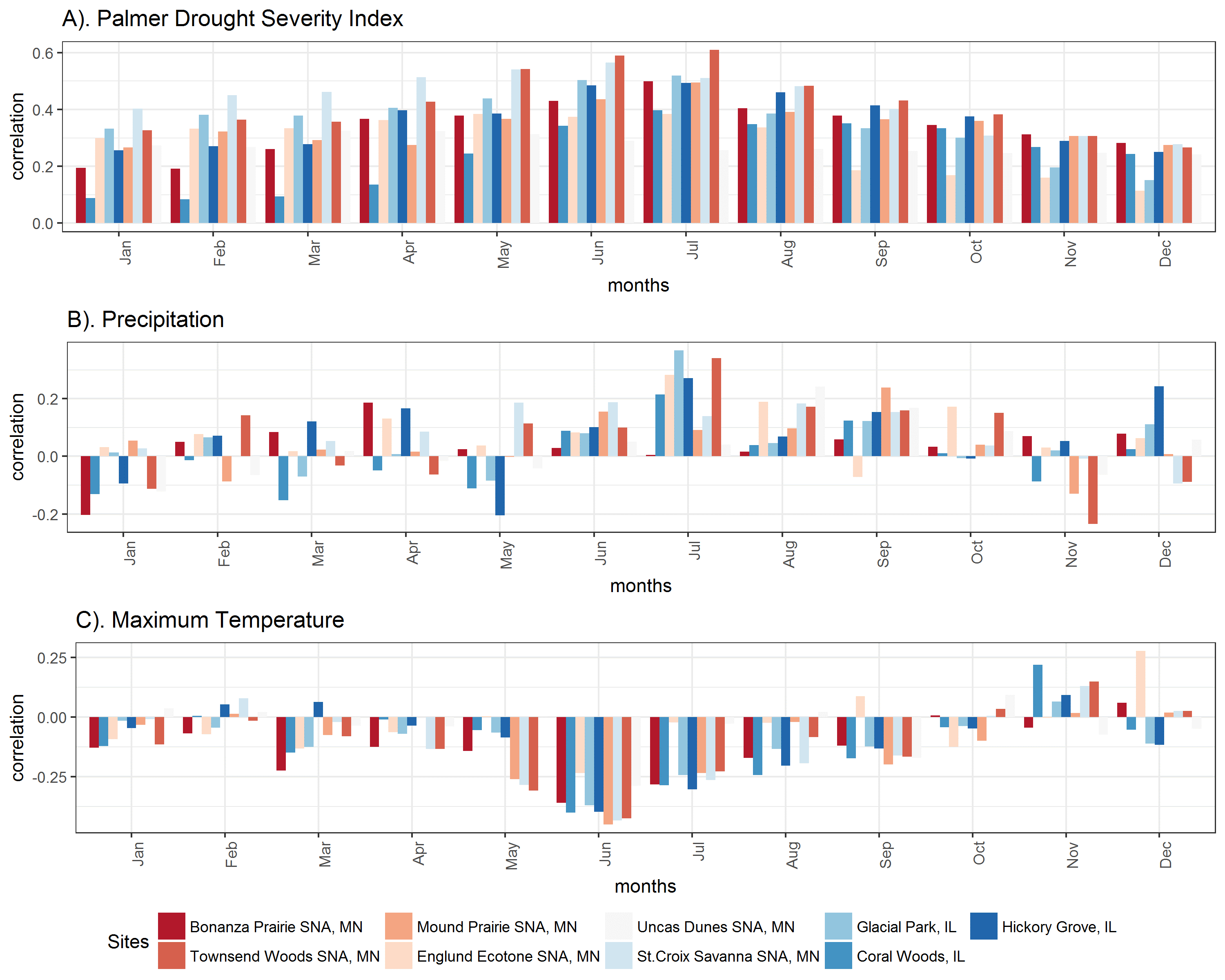
Correlations with monthly climate indicate that Oak trees at most sites are most sensitive to summer drought index and summer temperatures, but few are strongly sensitive to monthly precipitation. Red colored sites have lower mean annual precipitation, and blue sites have higher mean annual precipitation. A). Tree growth at all sites is most strongly correlated to summer drought (Palmer Drought Severity Index is positive in non-drought periods and negative in drought periods). B). July precipitation is only weakly correlated with growth at some sites. C). Tree growth is somewhat negatively correlated with summer maximum temperatures. (Click on image for a larger view.)

Have growth sensitivities changed over time?

The climate-growth relationship is often assumed to be constant for the purposes of climate reconstructions. However, recent dendroecological studies recognize that growth-climate relationships may change due to shifts in climate seasonality, changes in tree size class, tree competition, and possibly due to increases in atmospheric CO2 (Voelker et al. 2006). In theory, higher levels of CO2 in the atmosphere can enhance tree growth by increasing CO2 available for photosynthesis in the leaf, without changing stomatal conductance (gs, the amount of water that moves through the stomata). This results in an increase in plant Water Use Efficiency (WUE), or the amount of carbon taken up per unit of water used, which could help reduce the impacts of drought on trees (McCarroll and Loader 2004). While the effect of atmospheric CO2 on tree growth is still largely debated, past researchers found that Bur Oak (Quercus macrocarpa) trees in Western Minnesota have become less sensitive to drought since the beginning of the 20th century, and mortality due to drought has decreased  as well (Wyckoff and Bowers 2009). Additionally, Voelker et al. (2006) found that the positive effects on growth that may result from increased atmospheric CO2 likely decline with tree age. My sampling effort has extended the spatial range of oak sampling in the Midwest, allowing us to test whether a change in the growth–drought relationship over the 20th century is regional and if it has occurred in different oak species and site conditions.

With our data across the Midwest, we find preliminary evidence supporting a change in growth sensitivity to climate. Trees across the Midwest were less sensitive to drought after 1950, and younger trees established under high CO2 were also less sensitive to drought than older trees.

These results are consistent with the previous work in Minnesota (Wyckoff and Bowers 2009), and with a positive enhancement of CO2. In two of the three closed forest sites sampled, we find no difference in the growth-drought sensitivity over time, suggesting that savanna trees, but not forest trees have become less susceptible to drought in the region. While the stand structure (open savanna or closed forest) may help explain where we see shifts in growth-climate sensitivity, species sampled may also play a role, as well as the mean annual precipitation and temperature. To specifically test whether CO2 enhancement is driving the decreased drought sensitivity, I am currently working on a project that tests to see if the composition of carbon isotopes recorded within annual tree rings have changed. The ratio of heavy to light carbon isotopes can be used to quantify plant Water Use Efficiency, which will increase over time if CO2 has a net positive effect on tree growth.

Up Next…

This project is still ongoing and there are several questions that I am still exploring. I am continuing to work on a formal analysis of the tree ring growth data, and look more at species-specific sensitivities to climate, since the preliminary analyses focus on site specific responses.

If growth and sensitivity of growth to climate changes over time, I want to know if it is due to the effects of CO2, or some other factor affecting forest growth. This next year, I will be spending a lot of time in the lab quantifying stable carbon isotopes, to determine if plant WUE increases result in the decrease in drought sensitivity over time.


References:
Charney, N. D., et al. (2016). Observed forest sensitivity to climate implies large changes in 21st century North American forest growth. Ecology Letters, 19(9), 1119–1128. https://doi.org/10.1111/ele.12650

Goring, S. J., et al. (2016). Novel and Lost Forests in the Upper Midwestern United States, from New Estimates of Settlement-Era Composition, Stem Density, and Biomass. PLOS ONE, 11(12), e0151935. https://doi.org/10.1371/journal.pone.0151935

McCarroll, D., & Loader, N. J. (2004). Stable isotopes in tree rings. Quaternary Science Reviews, 23(7–8), 771–801. https://doi.org/10.1016/j.quascirev.2003.06.017

Peterson, D. L. (2014). Climate Change and United Steates Forests. In Climate Change and United States Forests. Springer. Retrieved from http://www.springer.com/us/book/9789400775145

Rhemtulla, J. M., et al. (2007). Regional land-cover conversion in the U.S. upper Midwest: magnitude of change and limited recovery (1850–1935–1993). Landscape Ecology, 22(1), 57–75. https://doi.org/10.1007/s10980-007-9117-3

Voelker, S. L., et al. (2006). Historical CO2 Growth Enhancement Declines with Age in Quercus and Pinus. Ecological Monographs, 76(4), 549–564.

Wyckoff, P. H., & Bowers, R. (2010). Response of the prairie–forest border to climate change: impacts of increasing drought may be mitigated by increasing CO2. Journal of Ecology, 98(1), 197–208. https://doi.org/10.1111/j.1365-2745.2009.01602.x

Identifying Local Fire Events From Sediment Charcoal Records Via Regularization

Post by Malcolm Itter, a graduate student with Andrew Finley at Michigan State University. Malcolm received an Outstanding Student Paper Award for this work at AGU 2016!

Charcoal particles deposited in lake sediments during and following wildland fires serve as records of local to regional fire history. As paleoecologists, we would like to apply these records to understand how fire regimes, including fire frequency, size, and severity, vary with climate and regional vegetation on a centennial to millennial scale. Sediment charcoal deposits arise from several sources including: 1) direct transport during local fires; 2) surface transport via wind and water of charcoal deposited within a lake catchment following regional fires; 3) sediment mixing within the sample lake concentrating charcoal in the lake center. A common challenge when using sediment charcoal records is the need to separate charcoal generated during local fire events from charcoal generated from regional and secondary sources. Recent work by PalEON collaborators including myself, Andrew Finley, Mevin Hooten, Phil Higuera, Jenn Marlon, Ryan Kelly, and Jason McLachlan applies statistical regularization to separate local and regional charcoal deposition allowing for inference regarding local fire frequency and regional fire dynamics. Here we describe the general concept of regularization as it relates to paleo-fire reconstruction. Additional details can be found in Itter et al. (Submitted).

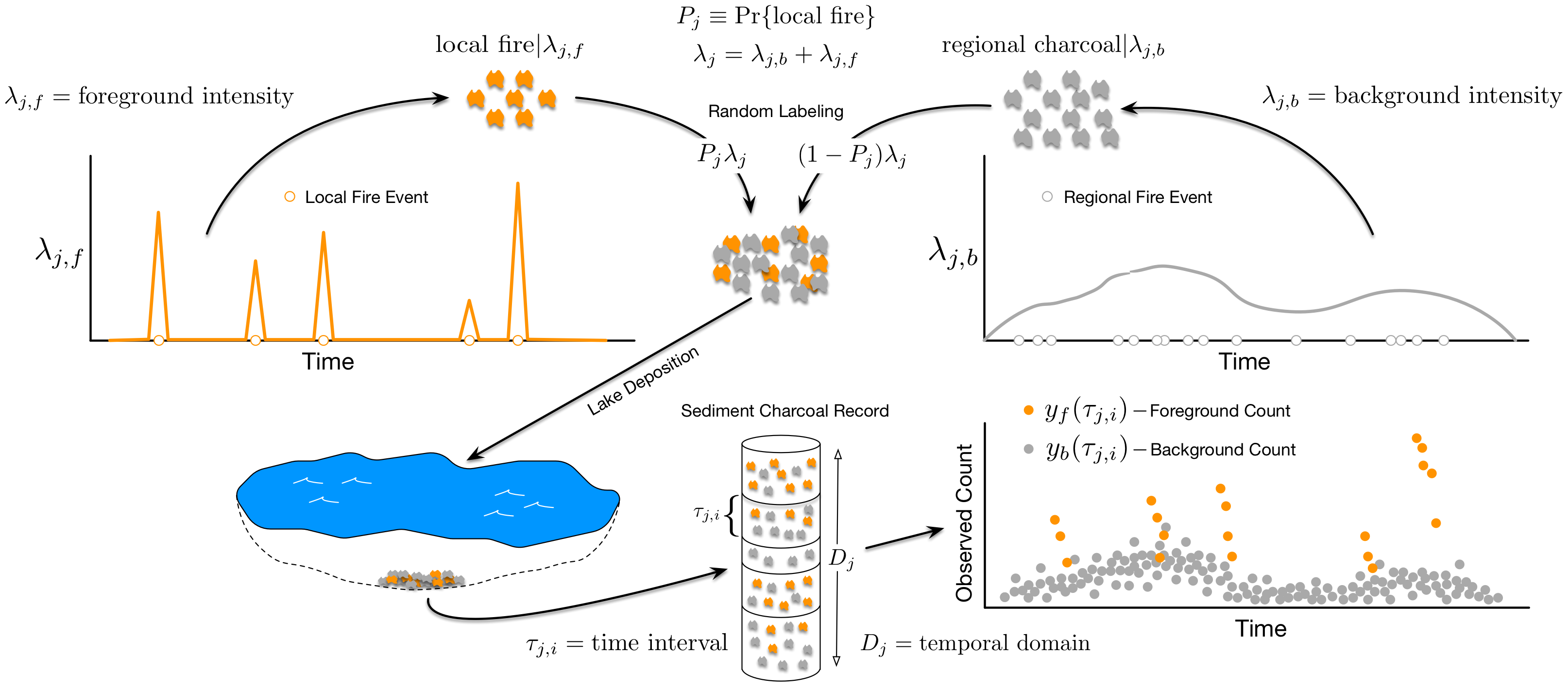
Figure 1: Illustration of theoretical charcoal deposition to a lake if charcoal particles arising from regional fires were distinguishable from particles arising from local fires (in practice, charcoal particles from different sources are indistinguishable). The figure does not depict charcoal arising from secondary sources such as surface water runoff or sediment mixing.

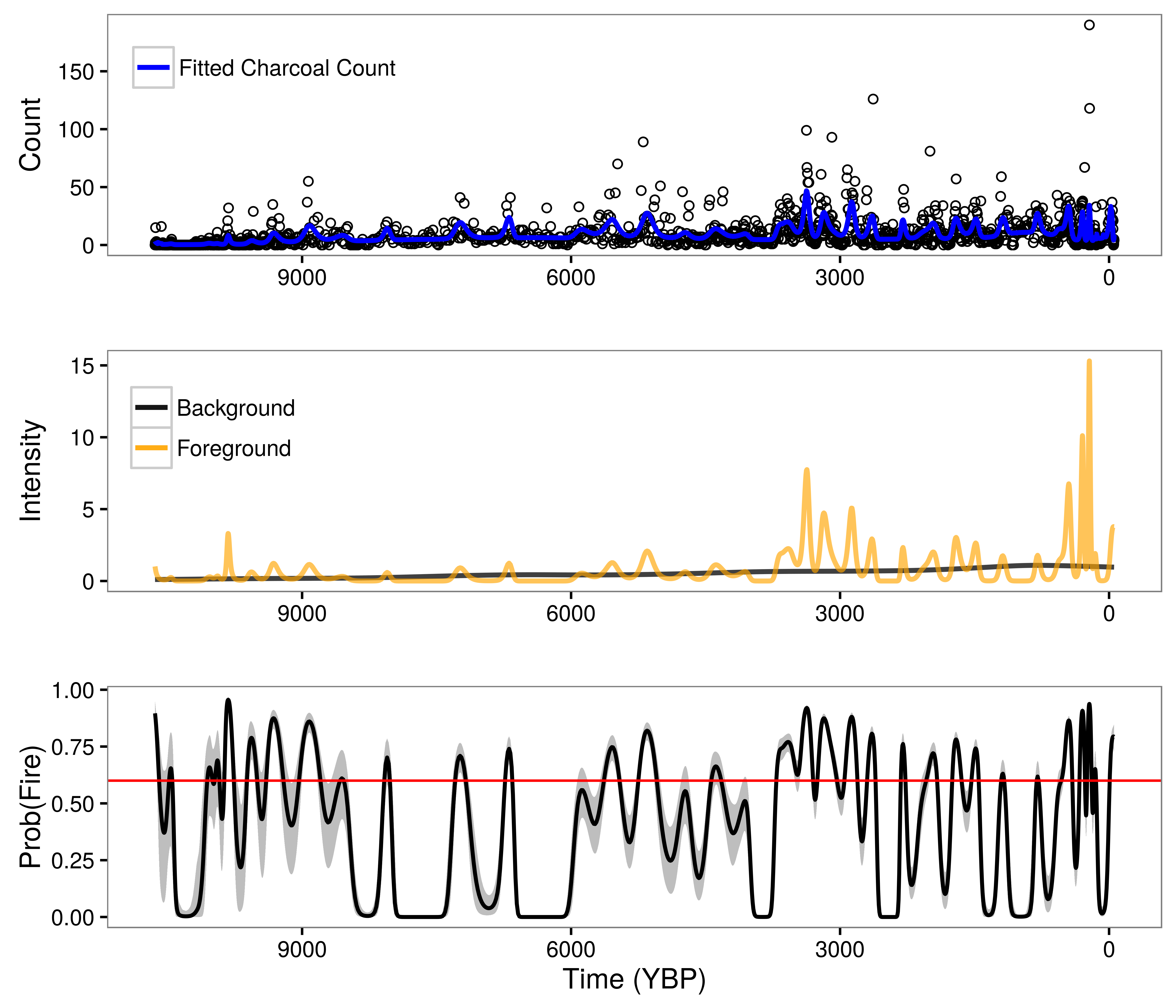
Figure 1 illustrates primary and regional charcoal deposition to a sample lake. We can think of charcoal deposition to a sample lake as being driven by two independent processes in time: a foreground process driving primary charcoal deposition during local fires, and a background process driving regional and secondary charcoal deposition. In practice, charcoal particles arising from different sources are indistinguishable in sediment charcoal records. We observe a single charcoal count over a fixed time interval. Direct estimation of foreground and background processes is not possible without separate background and foreground counts. We overcome the lack of explicit background and foreground counts by making strong assumptions about the nature of the background and foreground processes. Specifically, we assume the background process is smooth, exhibiting low-frequency changes over time, while the foreground process is highly-variable, exhibiting high-frequency changes in charcoal deposition rates associated with local fires. These assumptions follow directly from a long line of paleoecological research, which partitions charcoal into: 1) a background component that reflects regional charcoal production varying as a function of long-term climate and vegetation shifts; 2) a peak component reflecting local fire events and measurement error.

We use statistical regularization to ensure the assumption regarding the relative smoothness and volatility of the background and foreground processes is met. Under regularization, we seek the solution to an optimization problem (such as maximizing the likelihood of a parameter) subject to a constraint. The purpose of the constraint, in the context of Bayesian data analysis, is to bound the posterior distribution to some reasonable range. In this way, the constraint resembles an informative prior distribution. Additional details on statistical regularization can be found in Hobbs & Hooten (2015) and Hooten & Hobbs (2015).

In the context of sediment charcoal records, we model two deposition processes under the constraint that the background process is smooth, while the foreground process is volatile. We use unique sets of regression coefficients to model the background and foreground processes. Both sets of regression coefficients are assigned prior distributions, but with different prior variances. The prior variance for the foreground coefficients is much larger than the prior variance for the background coefficients. The prior variance parameters serve as the regulators (equivalent to a penalty term in Lasso or ridge regression) and force the background process to be smooth, while allowing the foreground process to be sufficiently flexible to capture charcoal deposition from local fires.

Figure 2: Model results for Screaming Lynx Lake, Alaska. Upper panel indicates observed charcoal counts along with the posterior mean charcoal count (blue line). Middle panel illustrates posterior mean foreground (orange line) and background (black line) deposition processes. Lower panel plots posterior mean probability of fire estimates for each observed time interval (black line) along with the upper and lower bounds of the 95 percent credible interval (gray shading) and an optimized local fire threshold (red line).

Figure 2 shows the results of regularization separation of background and foreground deposition processes from a single set of charcoal counts for Screaming Lynx Lake in Alaska. The probability of fire values presented in the lower panel of Figure 2 follow from the ratio of the foreground process relative to the sum of the background and foreground processes. We would not be able to identify the background and foreground processes without the strong assumption on the dynamics of the processes over time and the corresponding regularization. The benefits of using such an approach to model sediment charcoal deposition are: 1) our model reflects scientific understanding of charcoal deposition to lakes during and after fire events; 2) we are able to identify local fire events from noisy sediment charcoal records; 3) the background process provides a measure of regional fire dynamics, which can be correlated with climate and vegetation shifts over time.

References
1. Hobbs, N.T., Hooten, M.B. 2015. Bayesian Models: A Statistical Primer for Ecologists. Princeton University Press, Princeton, NJ.
2. Hooten, M.B., Hobbs, N.T. 2015. A guide to Bayesian model selection for ecologists. Ecololgical Monographs, 85, 3-28.
3. Itter, M.S., Finley A.O., Hooten, M.B., Higuera, P.E., Marlon, J.R., Kelly, R., McLachlan, J.S. (Submitted). A model-based approach to wildland fire reconstruction using sediment charcoal records. arXiv:1612.02382

State Data Assimilation and PalEON

Post by Michael Dietze and Ann Raiho

What is state data assimilation (SDA)?

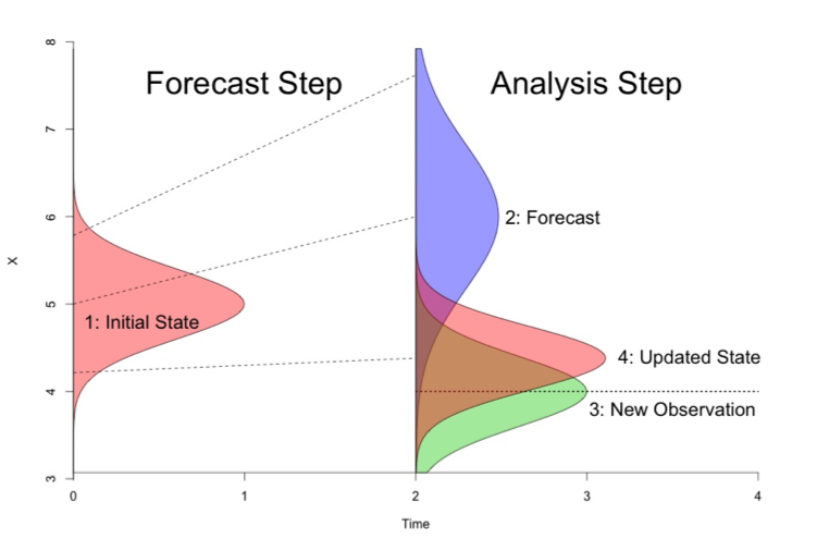
SDA is the process of using observed data to update the internal STATE estimates of a model, as opposed to using data for validation or parameter calibration. The exact statistical methods vary, but generally this involves running models forward, stopping at times where data were observed, nudging the model back on track, and then restarting the model run (Figure 1). The approached being employed by the modeling teams in PalEON are all variations of ENSEMBLE based assimilation, meaning that in order to capture the uncertainty and variability in model predictions, during the analysis step (i.e. nudge) we update both the mean and the spread of the ensemble based on the uncertainties in both the model and the data. Importantly, we don’t just update the states that we observed, but we also update the other states in the model based on their covariances with the states that we do observe. For example, if we update composition based on pollen or NPP based on tree rings, we also update the carbon pools and land surface fluxes that co-vary with these.

Figure 1. Schematic of how state data assimilation works. From an initial state (shown as pink in the Forecast Step) you make a prediction (blue curve in the Analysis step). Then compare your data or new observation (green in the Analysis step) to the model prediction (blue) and calculate an updated state (pink in the Analysis step).

There are many components in the PalEON SDA and many people are involved. In all methods being employed by PalEON modeling teams, the uncertainty in the meteorological drivers is a major component of the model ensemble spread. Christy Rollinson has developed a workflow that generates an ensemble of ensembles of meteorological drivers – first she starts with an ensemble of different GCM’s that have completed the ‘last millennia’ run (850-1850 AD) and then downscales each GCM in space and time, generating an ensemble of different meteorological realizations for each GCM that propagates the downscaling uncertainty. John Tipton and Mevin Hooten then update this ensemble of ensembles, providing weights to each based on their fidelity with different paleoclimate proxies over different timescales. In addition to the meteorological realizations, some of the techniques being employed also accommodate model parameter error and model process error (which is like a ‘residual’ error after accounting for observation error in the data).

Why are we doing SDA in PalEON?

In the PalEON proposals we laid out four high-level PalEON objectives: Validation, Inference, Initialization, and Improvement. Our previous MIP (Model Intercomparison Project) activities at the site and regional scale were focuses specifically on the first of these, Validation. By contrast, SDA directly informs the next two (Inference, Initialization). Both the SDA and the MIP indirectly support the fourth (Improvement).

In terms of Inference, the central idea here is to formally fuse models and data to improve our ability to infer the structure, composition, and function of ecosystems on millennial timescales. Specifically, by leveraging the covariances between observed and unobserved states we’re hoping that models will help us better estimate what pre- and early-settlement were like, in particular for variables not directly related to our traditional paleo proxies (e.g. carbon pools, GPP, NEE, water fluxes, albedo). The last millennium is a particularly important period to infer as it’s the baseline against which we judge anthropogenic impacts, but we lack measurements for many key variables for that baseline period. We want to know how much we can reduce the uncertainty about that baseline.

In terms of Initialization, a key assumption in many modeling exercises (including all CMIP / IPCC projections) is that we can spin ecosystems up to a presettlement ‘steady state’ condition. Indeed, it is this assumption that’s responsible for there being far less model spread at 1850 than for the modern period, despite having far greater observations for the modern. However, no paleoecologist believes the world was at equilibrium prior to 1850. Our key question is “how much does that assumption matter?” Here we’re using data assimilation to force models to follow the non-equilibrium trajectories they actually followed and assessing how much impact that has on contemporary predictions.

Finally, SDA gives us a new perspective on model validation and improvement. In our initial validation activity, as well as all other MIPs and most other validation activities, if a model gets off to a wrong start, it will generally continue to perform poorly thereafter even if it correctly captures processes responsible for further change over time. Here, by continually putting the model back ‘on track’ we can better assess the ability of models to capture the system dynamics over specific, fixed time steps and when in time & space it makes reasonable vs unreasonable predictions.

SDA Example

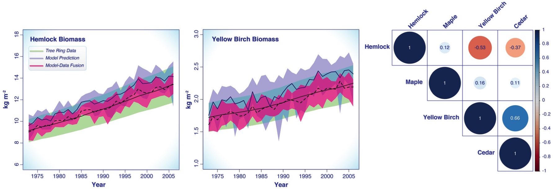
Figure 2 shows a PalEON SDA example for a 30 year time period using tree ring estimates of aboveground biomass for four tree species from data collected at UNDERC and a forest gap model called LINKAGES.  The two plots show the tree ring data for hemlock and yellow birch in green, the model prediction in purple and the pink is how the data “nudge” the model. The correlation plot on the right represents the process error correlation matrix.  That is, it shows what correlations are either missing in LINKAGES or are over represented. For example, the negative correlations between hemlock vs. yellow birch and cedar suggest there’s a negative interaction between these species that is stronger than LINKAGES predicted, while at the same time yellow birch and cedar positively covary more than LINKAGES predicted. One interpretation of this is that hemlock is a better competitor in this stand, and yellow birch and cedar worse, than LINKAGES would have predicted. Similarly, the weak correlations of all other species with maple doesn’t imply that maples are not competing, but that the assumptions built into LINKAGES are already able to capture the interaction of this species with its neighbors.

Figure 2. SDA example of aboveground biomass in the LINKAGES gap model. The left and middle plots are the biomass values through time given the data (green), the model predictions (purple), and the updated model-data output (pink). The plot on the right is a correlation plot representing the process error correlation matrix.


PalEON at AGU 2016

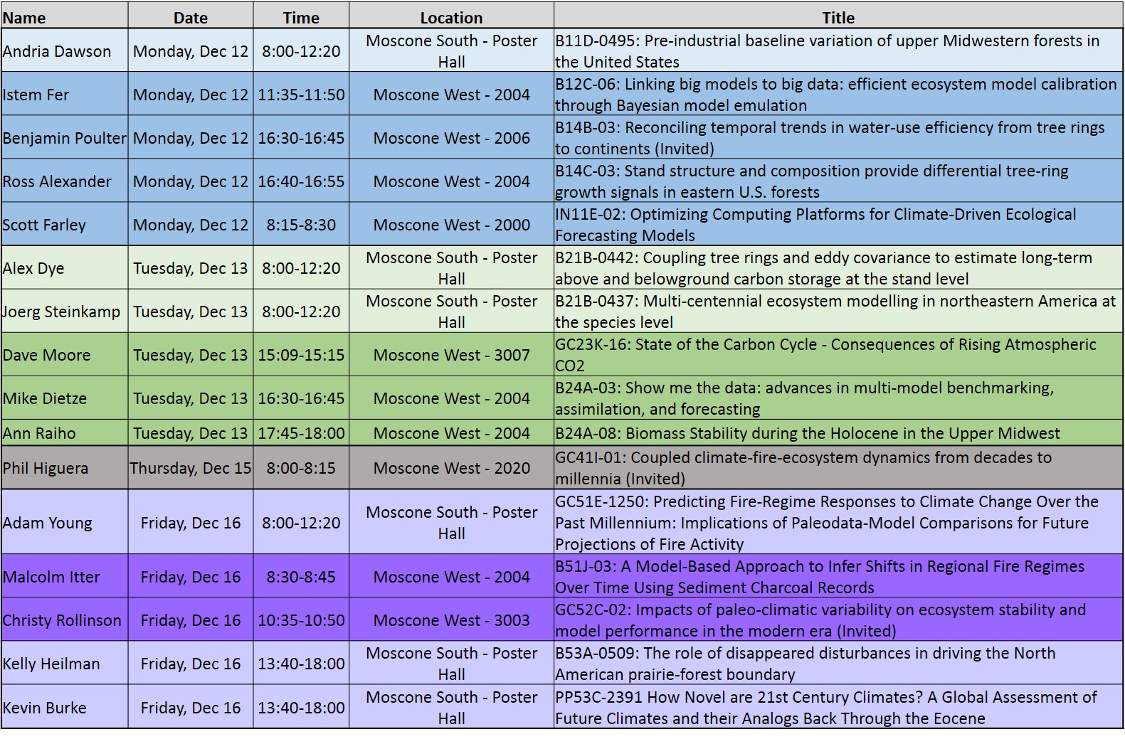
If you are going to AGU this year make sure to stop by and check out what PalEON has been working on!

AGU 2016 PalEON schedule color coded by day with lighter colors being posters, darker colors talks

AGU 2016 PalEON schedule color coded by day with lighter colors being posters, darker colors talks

Expert Elicitation to Interpret Pollen Data

Post by Andria Dawson, Post-Doc at the University of Arizona and the University of California-Berkeley

Fossil pollen counts from sediments collected from bogs, lakes, or forest hollows tell us something about the composition of surrounding forests (read more about fossil pollen here and here). In a sediment core, pollen samples from multiple depths tell us about changes in these surrounding forests over time. Barring some rare and complex geophysical events, going deeper means going back in time. With some simplifying assumptions about how pollen travels from tree to sediment we can use counts of sediment pollen grains to quantitatively reconstruct forests of the past.

However, correlating depth with time, or aging the sediment, is a difficult problem. Sediment accumulates at rates that vary through time, resulting in non-linear age-depth relationships. This means that knowing the sampling year – or the age of the surface sediment – is not enough to reliably estimate the ages of samples from further down in the sediment. This lack of information is solved with radiometric dating. Small pieces of plant material from the surrounding environment find their way into the sediment; these are macrofossils. Isotope signatures from these macrofossils can be used to determine their approximate age, and provide us with additional age-depth data points. Age-depth models can be constructed from these age-depth data points.

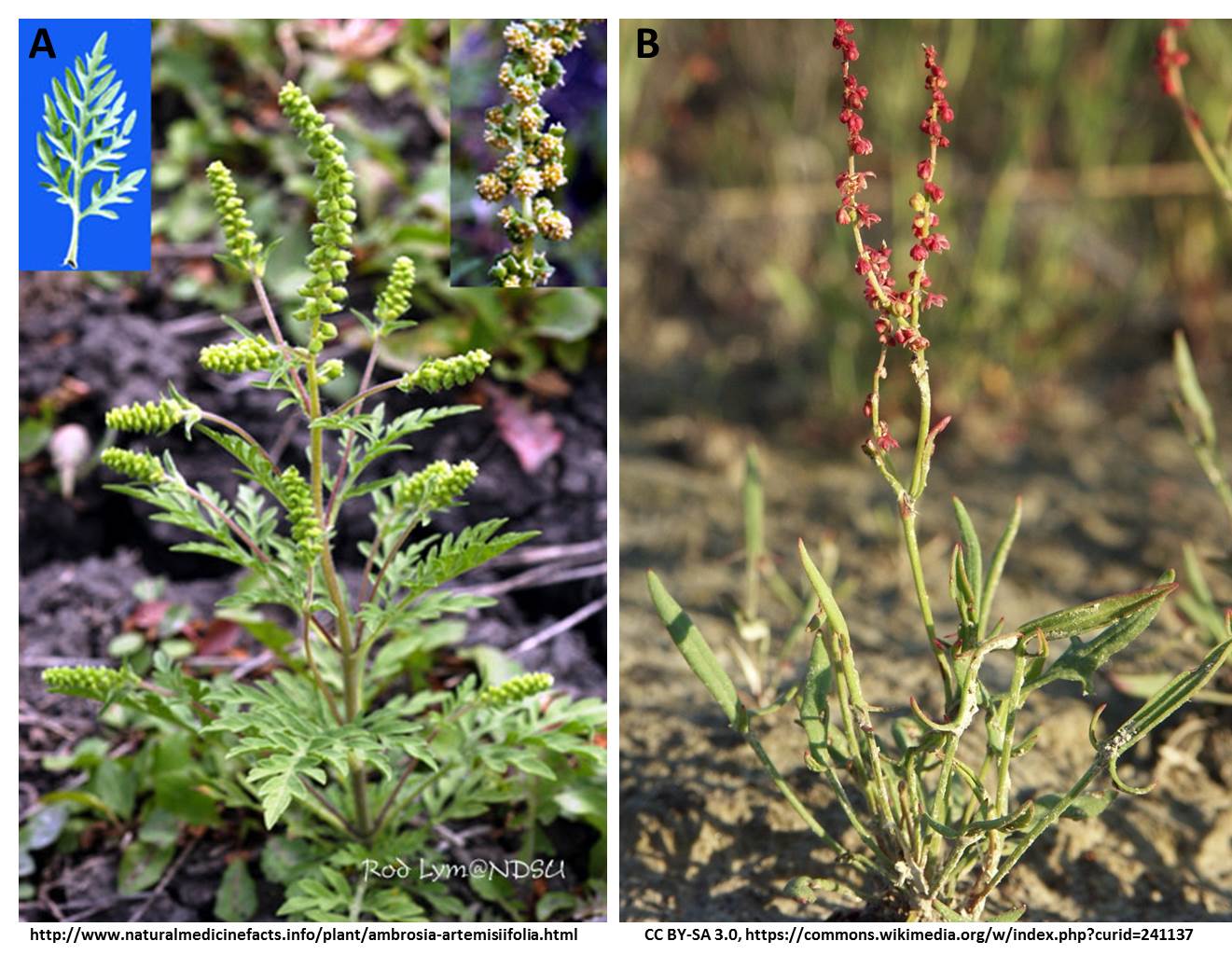
Another way to link depth with age is to look for signatory changes in pollen representation over time. Hallmark changes in the representation of indicator taxa allow scientists to associate sediment depths with events whose dates (ages) are roughly known. In the upper midwestern US, European settlement led to significant land-use changes which resulted in increases in several agricultural indicator taxa, including ambrosia (i.e., ragweed) and rumex (i.e., docks and sorrels) (Figure 1). This change in pollen representation makes it possible to identify pre- and post-settlement depths in a pollen sediment core. This matters because some scientists (including some of us on PalEON) hypothesize that major land-use changes probably caused big changes in the pollen-vegetation relationship. Were these anthropogenically-induced changes in the pollen-vegetation relationship greater than what we would expect without this external forcing? We don’t know, and might never know.

Images of A) ragweed and B) sheep sorrel.

Images of A) ragweed and B) sheep sorrel.

Nevertheless, we want to identify what we often refer to as the settlement horizon in the pollen records for at least two reasons. First, it allows us to compare pollen from the time of European settlement with public land survey records. Second, it is often used as an additional age-depth data point in the construction of age-depth models. But how easy is it to identify this settlement horizon? Recent work shows it is not as easy as one might have thought.

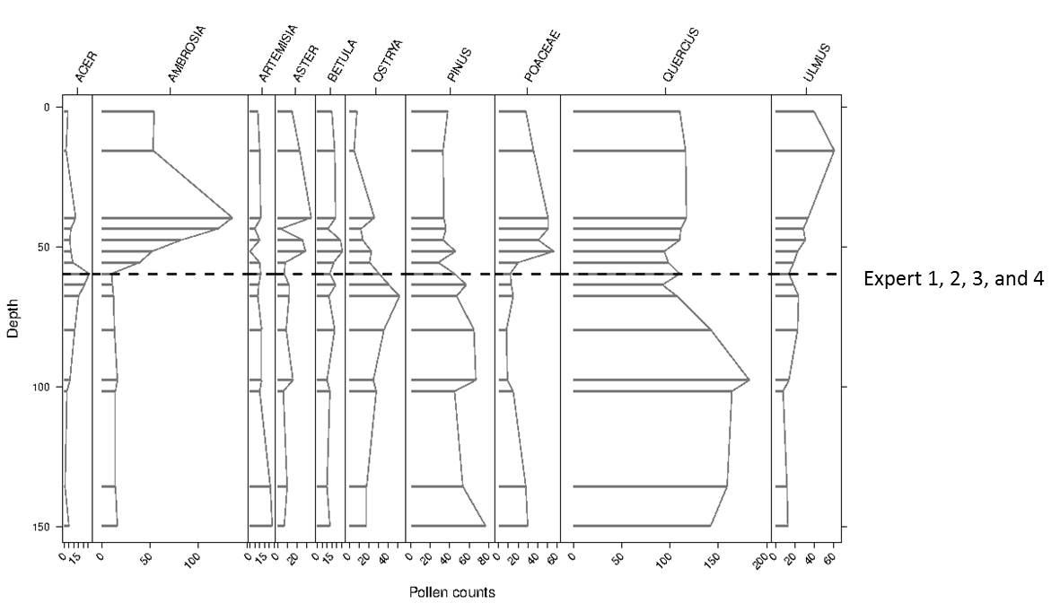
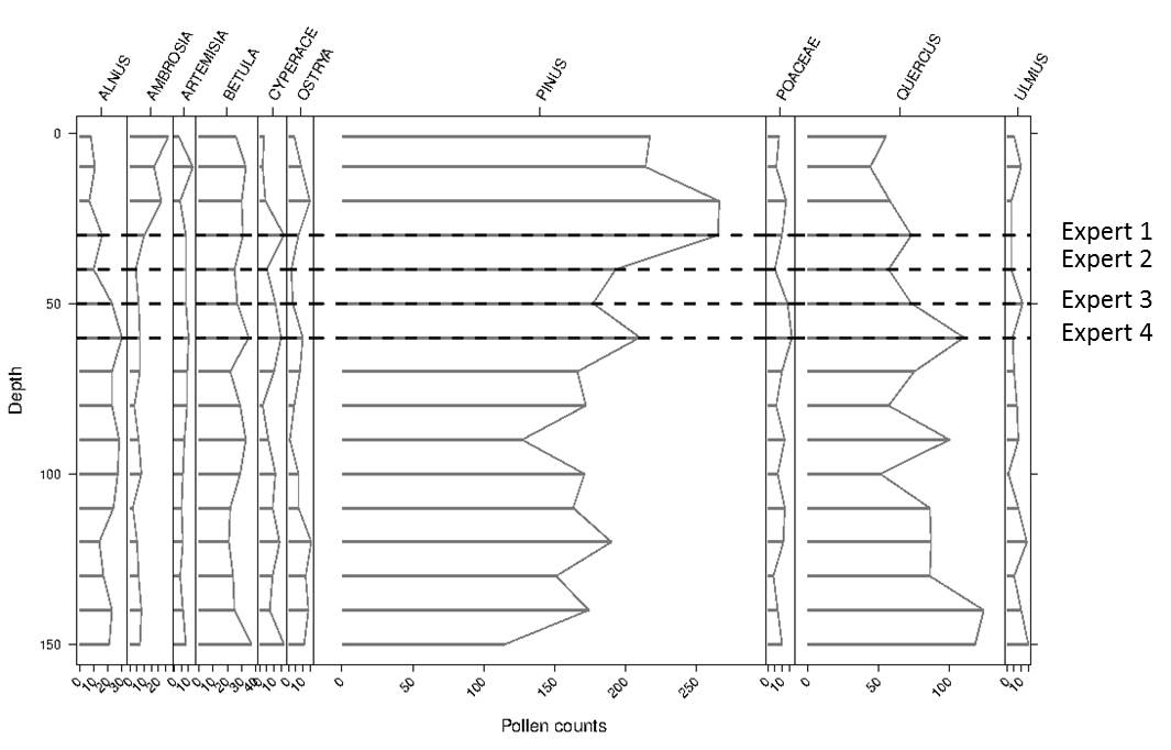
The unofficial PalEON mantra is that it is better to be correct and uncertain than certain and wrong. This line of thought led us to conduct an experiment using expert elicitation, where experts were tasked with identifying the settlement horizon in pollen records from the upper midwest. Four experts each considered 185 pollen records from the upper midwest USA. For 59 pollen records the experts agreed on the location of the settlement horizon (Figure 2). For the remaining records, there was some level of disagreement (Figure 3). This is not surprising, but does highlight the importance of thinking about uncertainty. Does this mean that we should disregard all previous attempts to identify the settlement horizon? The answer to this is a resounding no. The moral from all of this is that understanding your data is critical; understand its uncertainty and how this impacts your work. In the age of big-data and data-sharing, it becomes more difficult to really know your data, but the payoff is sound science. Know your data, and know it well.

To learn more about how we use results from the expert elicitation exercise referred to above, check out our recent Dawson et al. 2016 paper in Quaternary Science Reviews where we calibrate the pollen-vegetation relationship. Elicitation results have also been used to redefine controls for a new suite of age-depth models (Goring et al., in prep), which will in turn be used to assign dates to pollen samples used in vegetation reconstructions (Dawson et al, in prep).


Figure 2. Example of a pollen diagram from a site where experts were in complete agreement on the location of the representative pre-settlement sample. Samples identified by experts as pre-settlement are indicated by the dashed lines.

Figure 2. Example of a pollen diagram from a site where experts were in complete agreement on the location of the representative pre-settlement sample. Samples identified by experts as pre-settlement are indicated by the dashed lines.

Pollen Diagram Figure 3

Figure 3. Example of a pollen diagram from a site where experts were in complete disagreement on the location of the representative pre-settlement sample. Samples identified by experts as pre-settlement are indicated by the dashed lines.

References

  1. Dawson, Paciorek, McLachlan, Goring, Williams, Jackson. 2016. Quantifying pollen-vegetation relationships to reconstruct ancient forests using 19th-century forest composition and pollen data. Quaternary Science Reviews.137: 156-175. 
  2. Goring, Dawson, Grimm, et al. Semi-automated age model development for large scale databases. 2016. In prep for submission to Open Quaternary.
  3. Dawson, Paciorek, McLachlan, Goring, Williams, Jackson. 2016. Pre-industrial baseline variation of upper midwestern US vegetation. In prep for submission to Quaternary Science Reviews.