The Prairie Peninsula

Post by Will Chronister, University of Notre Dame Undergraduate Researcher

My project within PalEON explores the Prairie Peninsula, an intriguing feature of the pre-settlement Midwest that consisted of a bulge of prairie into Illinois and Indiana where forest was prevalent in surrounding areas. Human settlement and agriculture essentially wiped out the Midwestern prairie and replaced it with farms, towns, and forests, but in 1935, Ohio State University ecologist Edgar Transeau depicted the region as it originally existed. Transeau based his map on information contained in Public Land Survey (PLS) notes, which provide information about the landscape and were recorded when the land was first being explored and sold. However, Transeau’s map, while useful visually, lacks any accompanying data to characterize the prairies and forests of the time, and therefore has questionable accuracy. Furthermore, the map interestingly contains no indication of a prairie-forest transitional region.

Edgar Transeau’s 1935 Prairie Peninsula Map

In order to learn more about the Prairie Peninsula and determine the accuracy of Transeau’s map, we are gathering Illinois and Indiana PLS data from the old survey notes in townships within and around the Peninsula. This is helpful for my personal project and also contributes to the overall PalEON effort of collecting data from all of pre-settlement Illinois and Indiana. When we have enough townships completed, we will create a map of the vegetation and compare it to Transeau’s map. In addition to testing Transeau’s map, we will also look into the causes of the Prairie Peninsula, which may include such factors as precipitation, soils, hydrology, and so forth.

Ultimately this research is important for a couple of reasons. Firstly, it will be beneficial to confirm Transeau’s map of the Prairie Peninsula and/or create a better one so that we have an accurate picture of the 19th century Midwest. Secondly, if we can pin down the causes of this irregular region of prairie, it will inform the study of modern-day environments where the same processes could be taking place. Given the potential effects of climate change, the need to understand what causes a prairie to thrive in place of a forest, as well as other biome patterns, has never been more pressing. Our hope is that our research of the Prairie Peninsula can be a small contribution to this much-needed knowledge.

Why should we care?

Post by Jason McLachlan, University of Notre Dame Professor

On Friday, we had a film crew from a local natural history show Outdoor Elements on campus to film a couple of segments on PalEON. I led a segment on the changes in vegetation from the era of European settlement to the present and Sam Pecoraro led a segment on tree-rings. The host and director, Evie Kirkwood, asked each of us to come up with some photogenic activities and to think about why the Outdoor Elements viewers should care about our work.

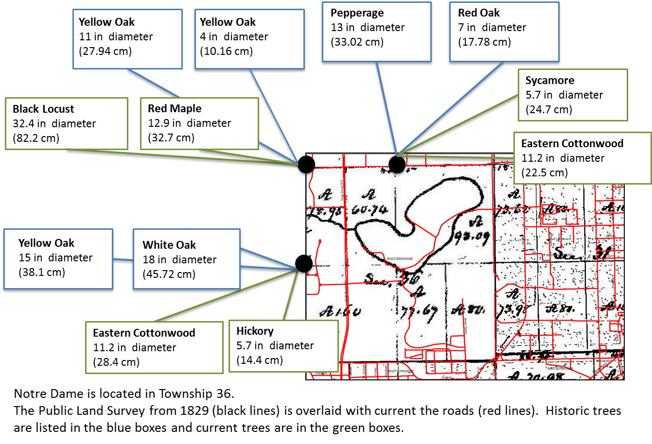
(1) The first part was easy. Jody and Zoe helped me pull together the settlement-era PLS survey data for the area that would later be the Notre Dame campus. Zoe and Jody overlaid the modern campus road system on top of the original survey map and the transition is striking. Back in 1829, when William Brookfield surveyed the area, Saint Joseph’s Lake and Saint Mary’s Lake are shown as a single lake (which was separated in the mid-1800s to reduce swampy lake margins). The creek draining this lake into the Saint Joseph River is now an underground culvert.


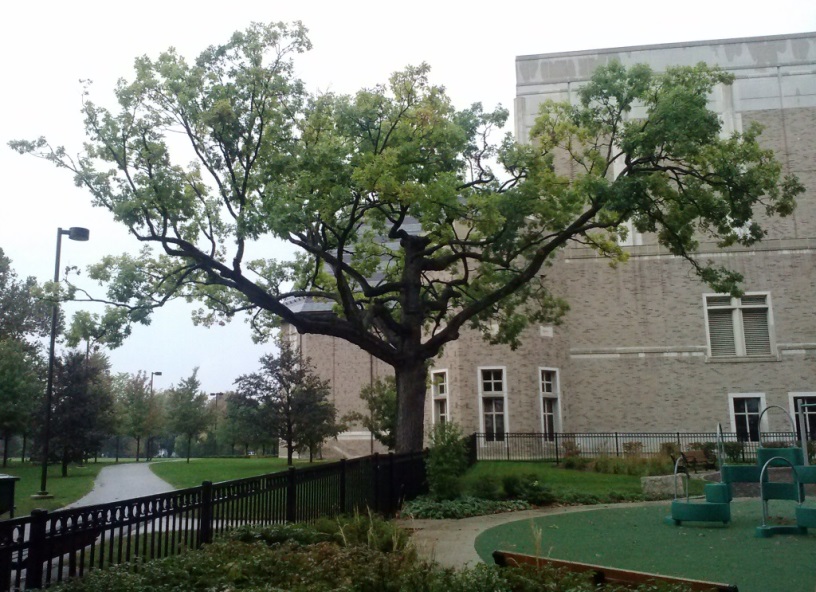
Resurveying the corner trees shows a transition to smaller trees in places that are now forested, and a transition to larger trees in open grown or ornamental settings. The broader settlement-era landscape includes long-gone features like the “Portage Prairie” along the canoe portage to the Kankakee River. Evie asked us if any of the original settlement-era trees still existed. The only plausible candidate we know of is this white oak on campus. It’s size and open grown form make it a plausible survivor, but it’s hollow, so we don’t really know if it was around when William Brookfield first passed by.

Meanwhile, Sam cored trees at the resurveyed PLS points for the camera. Sam cuts a rugged figure in his field gear (no picture available) and he is far more articulate than I am. Chelsea Merriman had earlier helped him prepare replicate cores for analysis, so, like Julia Child, Sam was able to instantly pull out sanded and counted tree-cores for the show.

(2) Getting our message across was much clumsier for me. Evie Kirkwood is a real pro and she made it as easy as possible for us, but academics are trained to be bad communicators, I felt really stumbly trying to get the magnificence of PalEON across in 7 minutes.

Here’s what I wish I’d said:

“We care about this for two reasons: First, we think we know our home, but what we think is permanent is transitional. Everyone hates to see changes in their town, or their neighborhood, or the landscape of their youth, but these things always change. Even when William Brookfield surveyed this township in 1829, it was changing, recovering from the French and Indian wars. (Everyone should read Richard White’s, “The Middle Ground”). PalEON shows us the pace and character of this change, so we can understand where we live.

Second, we know a lot about how the world will change moving forward, but not enough. The models we have for anticipating our impact on the atmosphere and the biosphere are stunningly clever and powerful. But they are also too simple (they are supposed to be simple). I’m not sure if we will ever provide the accurate forecasts that policymakers seek, but our best effort will combine these models with data on how ecosystems really change. That’s what PalEON does.”

Here’s what I actually said:

Actually, I don’t remember what I actually said. I was really nervous. What I was thinking was: “Am I supposed to look at Evie or the guy with the camera? Did I just stick my arm right in front of Zoe’s face? Shit. I forgot to mention the changing stem densities! Does this new haircut make my face look fat?”

Luckily for me, Evie is a good editor; we gave them a lot of good visuals; and Sam is a natural in front of the camera. Everyone says I didn’t look nervous and I made sense. We’ll see when the show hits the air in 2014.

PLS around Notre Dame

Posted by Jody Peters

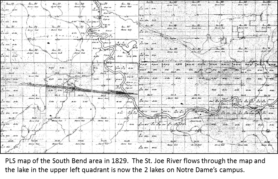
The crew at Notre Dame is in the process of entering PLS data for Indiana. Recently we focused on the area around Notre Dame and South Bend. Here is the area as depicted in the 1829 PLS survey, 13 years before Notre Dame’s founding.
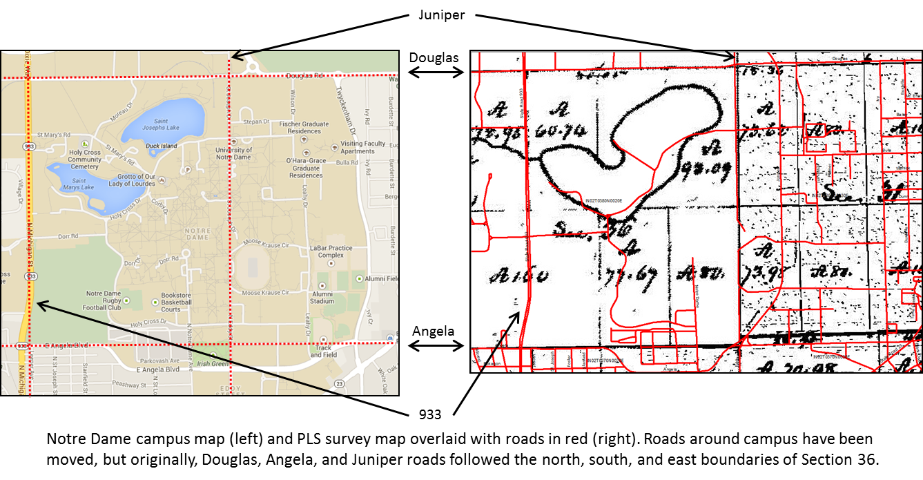
It has been interesting to learn about the changes that have taken place around campus. While the major roads around Notre Dame (Angela, Douglas and Juniper) were originally based off the PLS survey, all three roads have had sections of them moved.


In the 1829 survey, the two lakes on campus were drawn as one. We aren’t sure if this is because the surveyor was in a hurry and didn’t take time to explore the lakes further or if he was surveying in the winter when the lakes were ice covered. But from historical documents at Notre Dame there are a number of references to two lakes, although the lakes water levels have been known to fluctuate and at some points were quite high making the area between the lakes quite swampy.
At the time of the PLS survey the Notre Dame area was dominated by oaks. But another tree found in the area that was of interest to the lab was the pepperage tree. The pepperage tree, or more commonly spelled, pepperidge is also known as sour gum, black gum or black tupelo. As a side note, the pepperidge tree is where Pepperidge Farms get their name (got to love those goldfish crackers)! To learn more about pepperidge trees, check out this great site. Keep up to date with ND’s data entry progress by clicking on Indiana map at our Settlement Vegetation Site.


PalEON Settlement-era Vegetation Meeting

Jack Williams hosted a meeting on settlement-era vegetation at the University of Wisconsin from Oct 11-12, 2011. Attendees discussed the details of the orginal land survey records, plans for the extension of data collection to Ohio, Indiana, and Illinois, and methods for their analysis and integration into modeling efforts.