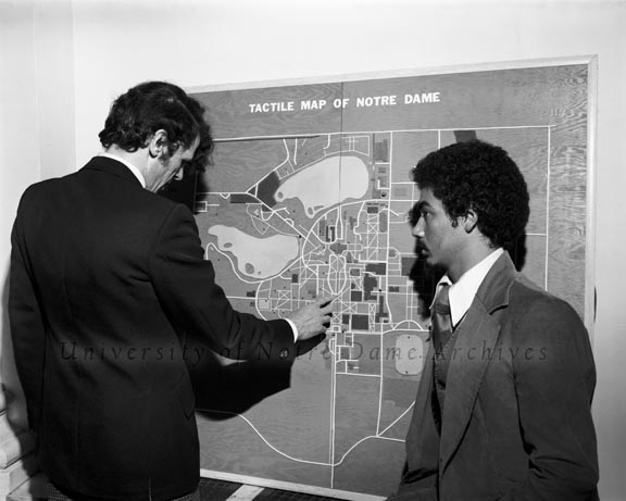

In the spring semester of 1978, fifth-year Architecture student Leroy Courseault developed a tactile map of campus for the visually impaired. Courseault distinguished the buildings, roads, and terrain with different types of materials with different textures, such as various grades of sandpaper, wire, and rubber.
 Dr. Stephen J. Rogers Jr. explores a textured campus map as Architecture student Leroy Courseault, who designed and constructed the map, looks on, 1978/0515
Courseault consulted on his project with Dr. Stephen J. Rogers Jr. of the General program of Liberal Studies, who was the only blind faculty member at the time. Rogers “found that the mental picture of the campus he had developed over the years turned out to be fairly accurate. ‘But with Leroy’s map, I learned some things I never knew before,’ he said. ‘It’s a marvelous success as a tactile instrument'” [UDIS 211/23].
Courseault also intended to add audio effects to the map to help orientate the visually impaired. He planned to link sounds such as the Basilica bells, ducks at the lakes, or street noise, which are unique to certain areas of campus.
The tactile map located in the Main Building. It is unclear when it was removed. The most recent reference to it is 1984 in the University Archives’ online finding aids.
Sources:
UDIS 211/23
GPHR 22/4224
Interesting Campus Map Archive page, Keep up the good work.
I wonder if that map could be used for those that have a hard time in life just to get off the streets and get a good education via a sports scholarship by playing baseball?
I think pitching machines for baseball are like that map of the campus and baseball stadium were back in 1978. You need one to get to the next level.
I think the map idea was magnificent! Bring it back! Kind of like, lets bring back the old baseball music of ester-year, as these were great memories of the great game of baseball!
Unfortunately, we don’t think that it still exists. It was probably taken down when exhibits were installed in Main Building for the Sesquicentennial in 1991. At that point, the 1978 map would have been very much out of date and perhaps it was a bit too tedious to consider maintaining.