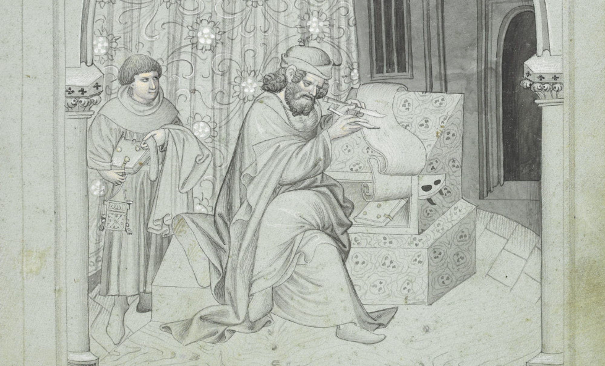
When students take a literature class, they often expect the familiar routine: read, analyze, write essays, repeat. But what happens when we shake it up and ask them to step creatively into the voices of the historical figures they’re studying? The results, as I’ve discovered in my teaching, can be transformative.
Benjamin Bloom’s 1956 taxonomy of knowledge, still considered a pedagogical standard (with some revisions), suggests that creating is the highest level of learning. When students can take apart information and put it back together again in a new way, they’ve fully integrated that knowledge into themselves. It’s not just remembering a rote list of facts (level 1) or understanding what those facts means (level 2). It’s not applying facts and ideas to real-world situations (level 3) or analyzing what different components make up ideas (level 4). Nor is it evaluating (level 5) — scrutinizing and making judgments about information and ideas.
Bloom’s revised taxonomy organized as a pyramid of learning levels with explanations of each, created by Tidema. CC-BY-4.0, Wikimedia.
When my students turn in creative assignments, I get to see all the levels at work: have they remembered and understood what’s happening in the readings and the historical facts? Have they caught key themes and concepts? Are they able to answer questions about them? Have they correctly identified the components of the information and concepts? Can they judge what is biased versus factual, what information is reliable and what is suspect? And then finally, when they blend it all together in a creative way, I can see what they’ve truly learned. Any concepts they haven’t quite grasped stand out clearly, and we can work on those further.
While I use creative writing in a literature class—a natural fit—it can be used in any subject, in and outside of the humanities. Have your theology student write a letter to God. Have your aerospace engineering student write a story about designing a turbine blade. Have your computer science student write a haiku in binary code. This approach works for any subject matter.
And let’s not forget the importance of fun! These assignments are often far more engaging for students to write than yet another analytical research paper. And they’re more enjoyable for us professors to read too.
If you’re worried about academic rigor, don’t be: you can ask your students to include a short essay reflecting on the process of creation. What sources and research did they engage with? Why did they choose that particular diction and imagery? What parts of the class readings inspired them? (This reflection process also uses Bloom’s highest level, creating).
Reader Responses: A Simple Starting Point
Let me show you one of the simplest ways I use creative assignments: reader responses in my course “Witches, Warriors, and Wonder Women: Women, Power, and Writing in History.” It’s a second-year course that meets both Fine Arts and Literature and Writing Intensive curriculum requirements.
I present the reader responses and creative option in my syllabus this way:
Written reader responses, 15%. Let’s dive into some reader responses! You’ll need to submit 10 of these total (no more than one per module). Each response should be about one double-spaced page. Be sure to turn it in before we discuss that person in class (for example, bring your Joan of Arc response on a day we talk about her). Graded ✓+ (3 points), ✓ (2 points), ✓- (1 point), or 0 points for not turned in.
(a) Feeling creative? You can mix it up! For up to 5 of your responses, write something in the voice of the historical figure we’re studying (like Boudica or Joan of Arc). Just make sure it shows you’ve really connected with the texts.
(b) Prefer prose? Submit 5 or more responses that explore how the historical figure and the texts about her make you think about women, power, and writing. Don’t forget to back up your thoughts with quotes (include page numbers too!).
A surprising number of students choose Option A pretty frequently! (This particular class is in Medieval Studies, cross-listed with English, History, and Gender Studies. It often attracts the lit kids and poets so I know I’m going to get some fantastic creative writing—but students in all majors turn in remarkable work!
Three of my students volunteered to let me publish their writing here.
Boudica: Celtic Warrior Queen
By Paul Walter—Boudica statue, Westminster, London, England. CC BY 2.0, Wikimedia
The first piece was written by civil engineering student Kate Ancona in the voice of Boudica, Celtic warrior-queen. We had read Tacitus’s account of Boudica and the uprising she led in about 61 A.D. against the Romans occupying Britain; we had also read William Cowper’s “Boadicea, An Ode” (1782). Kate captured beautiful details from Tacitus (like her flaming hair ) and drew inspiration from Cowper’s metrics. She meditates on Boudica’s iron strength, her fierce warriorhood, her quest for revenge against the violence done to her and her daughters and to her Iceni people.
Queen of the Rebellion
By: Boudica
I stood tall against the storm, Iron in my veins, a mother’s scorn, For daughters shamed and lands defiled, I raised my sword, fierce and wild.
They came with chains, with fire and lies, But I, Boudica, would not be disguised, By their power, by their might, I called my people to the fight.
We lit the night with Roman fear, For every tear, for every year, I became the roar of ancient land, A queen who’d die, but never stand.
In history’s grip, I’ll hold my name, A woman’s strength, forever flame, Beneath the earth, my heart may rest, But my spirit rides, the warrior’s quest.
This second piece was written by psychology student Anastasia Tejeda about a lesser-known aristocratic British woman who perished in the English Civil War while defending her family home. Notice how Anastasia approached the assignment thoughtfully, presenting contextual details about Lady Brilliana and assembling many pieces of information to imagine the rallying speech she might have given before battle. We have diary entries from Lady Brilliana but no account from her during her final siege. We rely instead on the account of an observer, Captain Davies. Anastasia masterfully captures the rallying rhetoric of the battlefield, drawing on Queen Elizabeth’s Speech to the Troops at Tilbury, which we’d read shortly before Lady Brilliana.
Anastasia’s Introduction
Like Joan of Arc and Queen Elizabeth I before her, Lady Brilliana Harley held military command and power during a time of war. Defender of her family’s castle in her husband’s absence during the English Civil War, she endured and emerged victorious as a Parliamentarian in a seven-week-long siege of the estate. Captain Priamus Davies, in his account of the siege, writes of the “honorable and gallant” Lady Harley and her confident, wise, and authoritative leadership (Hudson, The Grand Quarrel, 85). On August 22, 1643, the besieged received intelligence of the “low condition the Parliament party [was in] throughout the kingdom,” encouraging Harley to surrender (Hudson, 88). Yet far from despairing, Davies writes that “the noble lady protested that she would rather choose an honourable death, for she was confident that God would own His cause both in the public and private. We needed no better an encouragement” (Hudson, 89). This is the encouragement I imagine Harley would have given her troops on that night:
The Brampton Bryan Castle Address
My people, we have defended our home well thus far, and by the grace and care of God have proven ourselves brave and steadfast. I pledge to you, my loyal household, that as God has entrusted this estate to me to protect and preserve, He shall not abandon us now. So long as we stand here alive, so too is our cause alive, whatever news we hear from the outside. I urge you to remain firm and fight on against those who dare to make war against God and the sacred institution of Parliament. I will not abandon our commission for reason of fear. We shall fight, and fight nobly, certain of our favor with the Almighty, for should we perish, we shall perish nobly as well, preferring death to cowardice. I am confident in our imminent victory, and the glory and courage with which we will continue to fight until it is ours.
Anastastia’s Reflection on Creative Assignments
In composing a speech in the voice of Lady Harley, I was able to step inside her world, catching a glimpse of her convictions, passions, desires, and dreams, or what they might have been. When writing in prose on a historical figure, I am an outsider, evaluating and interpreting their life, drawing comparisons and conclusions about them. Speaking from the perspective of Lady Harley, I began to ask questions I never had before. What was she feeling at that moment? What were the words she would have said? Why would she choose these words and not others? I stepped into the voice of Lady Harley and learned who she was, not simply what she did.
Joan of Arc
Historiated initial depicting Joan of Arc. Public Domain, Wikimedia.
The third piece was written by Megan Ferrello, a history student, about Joan of Arc. Notice how Megan selected key details from Joan’s trials and stories written about her to get into Joan’s inner world. The only compositions we have directly from Joan—and even these are not certain—are a few letters written from the battlefield to rulers and to French cities. Megan pulled together details from various sources written about Joan, including her trial testimony, to weave a beautiful picture. Megan’s deliberate punctuation choices also reveal much about how she imagines Joan’s voice.
Joan of Arc: Reader Response—Poem
I led men into combat And it’s true I dressed as them But I battled under God’s order So why see me and condemn?
I have been beaten and battered and bruised But those were physical attacks I fear this quarrel you’ve brought me to Is something that from which I cannot come back
My only desire was to serve Him And perhaps in the end I did Yet the words of earthly men scream louder My actions they forbid
Like my holy Mother I remain untouched Though fire and flame consume me My purity I still clutch
I cry for Michael, for Catherine, for Margaret For they have never led me wrong I remain steadfast in my devotion So, to Heaven’s arms I now belong
They labeled me a heretic and an idolater But history will know the truth Of a girl who fought for God and Country Who was taken down in her youth
While my end was unjust, you must remember How the story did actually end Not of the flames, and the tears, and the dread But of the maiden who refused to bend
Megan’s Reflection on Creative Assignments
I really enjoyed having the creative options for reader responses, as I loved to write poetry when I was young, and these assignments have gotten me back into it! It even enabled me to choose creative alternatives in other classes, which is unusual for me, since the feedback I received from completing poems in Witches, Warriors, and Wonder Women helped me grow in my confidence! I loved putting myself in the mind of the historical woman, and I think it allowed me to read the primary sources at a deeper level.
The Impact: What Creative Writing Reveals
See what happens when students move beyond traditional analysis into creativity? Each student discovered something different through the creative process—not just about their historical subjects, but about their own capacity for empathy, research, and synthesis. They weren’t just analyzing these women’s experiences; they were wrestling with the same questions of power, identity, and purpose that their subjects faced.
Creative writing assignments don’t replace rigorous analysis; they enhance it. When students create an imagined narrative or commentary, they engage more deeply with primary sources, consider multiple perspectives, and grapple with ambiguity in ways that traditional essays sometimes miss. They move from studying history to experiencing it, from analyzing literature to creating it.
Whatever you teach, consider how creative assignments might transform your students’ relationship with your subject matter. The results might surprise you—and them.
Megan J. Hall, Ph.D. Associate Director Medieval Institute University of Notre Dame
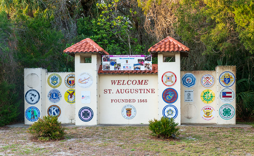
Few people, even Floridians, know about the medieval roots of St. Augustine discussed in my previous blog. In fact, if you’re planning a trip there and you Google “medieval St. Augustine,” you’ll only get results for the city’s Medieval Torture Museum or for the antique Christian philosopher St. Augustine of Hippo.
As readers of this blog know well, though, there is far more to any society, medieval or otherwise, than its methods of policing and punishment. Allow me, then, to take you on a medievalist’s tour of St. Augustine!
Welcome gateway in St. Augustine. Photo by the author.
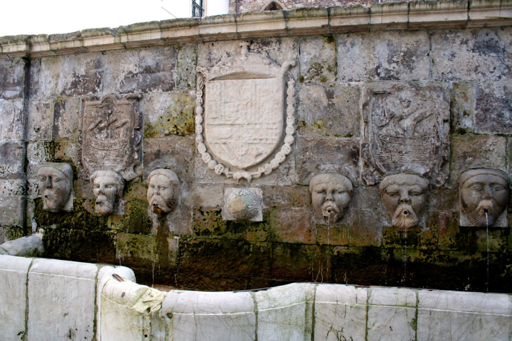
I recommend beginning at the St. Augustine Visitor Information Center. The parking is plentiful (though not free), the air conditioning glorious, and the informational brochures abundant. The VIC also has terrific museum-quality exhibits, including replicas of Spanish sailing ships and plenty of historical documents, explanatory placards, and artifacts. The plaza also houses a notable fountain, a replica of the Fuentos de los Caños de San Francisco (Fountain of the Spouts, in the Avilés neighborhood of San Francisco). St. Augustine’s sister city, Avilés, Spain, also the birthplace of St. Augustine’s founder Pedro Menéndez, gifted the fountain to St. Augustine in 2005. The original Fuentos de los Caños de San Francisco in Avilés was built in the sixteenth century, in the late medieval/early modern transitional period, and will set the medieval mood quite well for you!
Fuente de los caños en Avilés. Photography by Sitomon, posted to Wikimedia Commons.
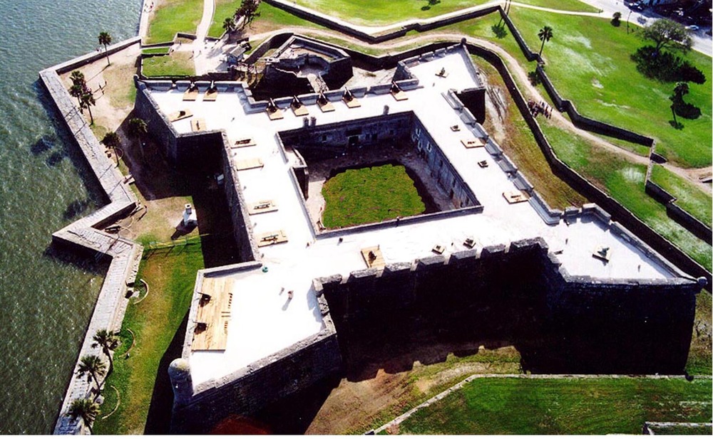
The Castillo de San Marcos
From the VIC you can walk east to the Castillo de San Marcos (the Fort of St. Mark, managed by the National Park Service). As you’ll see in your visit, the Castillo blends the functions of medieval stronghold and defensive New World frontier fort.
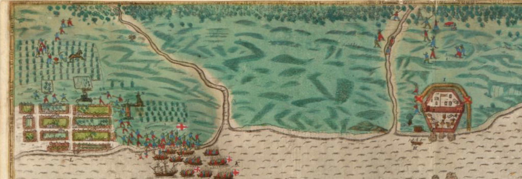
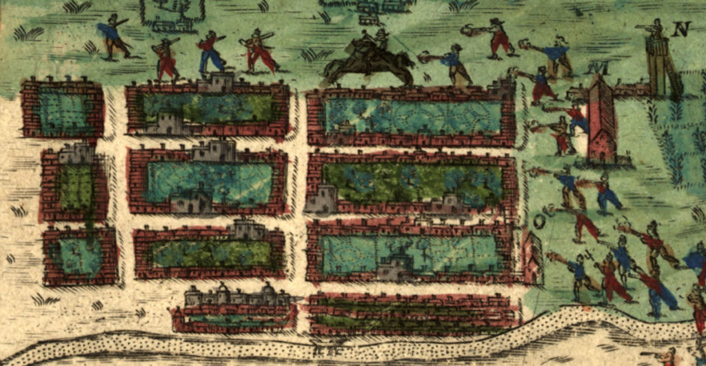
From the early days of the settlement, this spot held a defensive fort, though the earliest ones—nine in total—were wooden. [1] We know this from a significant map made by Baptisto Boazio, created to accompany a written account of Sir Francis Drake’s 1585 raiding expedition to attempt an upset of Spanish settlements in their new territories.
Close-up view of the Boazio map of St. Augustine, showing a wooden fort at the right, on the site of the present-day Castillo, and the first Spanish settlement at the left, with crop-growing fields at the top and right, and a watchtower, town house, and church to the right of the houses. Image from the Library of Congress.
In September 1585 Drake set out with 29 vessels. He and his crew raided and captured Santiago (Cape Verde), Santo Domingo (modern-day Dominican Republic), Cartagena (modern-day Columbia), and St. Augustine. The illustrations made by Boazio, who either went on the voyage or used information provided by Sir Francis Drake or other sailors, are the first recorded views of each of these locations, and his drawing of St. Augustine is particularly notable as the first recorded view of a European settlement in North America.
His maps were printed to accompany the written account two sailors kept of that voyage. Captain Walter Bigges began the account and kept it until he died in Cartagena; Lieutenant Croftes continued it after Bigges’s death. [2]
Croftes described St. Augustine’s fort as still in progress, only three or four months old, “all built of timber, the walles being none other but whole mastes or bodies of trees set uppe right and close together in manner of a pale, without any ditch as yet made.”[3] Drake and his company burned the unfinished fort, and the town, to the ground.
Though the fled survivors returned and rebuilt, much of the town was destroyed again just a few years later in a hurricane of 1599. Finally in 1672, the settlers began construction of a stone fort. Its first stage was finished in 1695 (the second stage ran from 1738–1756). [4]
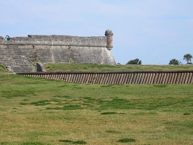
Though the structure of the stone fort, made of native coquina, was post-medieval, it served in many ways as a medieval castle, a defense for the town around it and a place for St. Augustinians to shelter when under assault. In 1702, for example, when the British attacked, “about 1,500 soldiers and civilians were packed into the Castillo for 51 days!” [5]
The courtyard had three freshwater wells, the dry moat and the glacis offered protection from invasion, and both the inner and outer fortress had cannons and other types of munitions for fending off attackers.
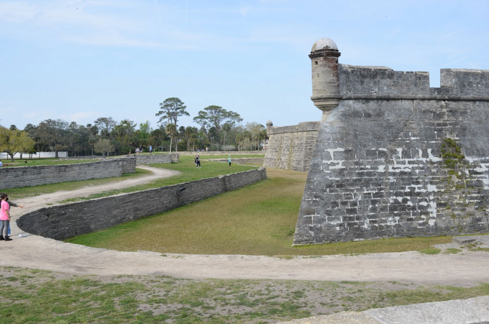
The southwest corner of the fort, showing the Bastion de San Pedro (each of the four angled corners of the fort contains a bastion, and each is named: NE, San Carlos (also the main watch tower); NW, San Pablo; SW, San Pedro; SE, San Agustín). Photo by the author.
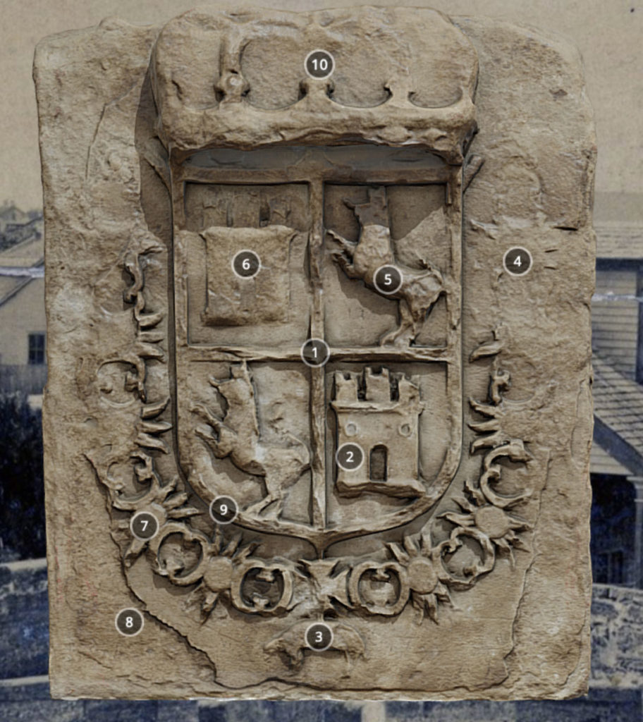
A medieval coat of arms appears above both the ravelin (the v-shaped protective installation at the south end) and the sally port (the entrance into the south wall, reached by the drawbridge and protected by the ravelin). As in the city coat of arms that I discussed in Part One, the lions represent the Kingdom of León and the castles the Kingdom of Castile, the crown atop Spain, and the sheep and enclosing chain the medieval Order of the Golden Fleece.
Image of the (replica) stone crest on the ravelin. Image from the NPS virtual tour of the Castillo.
Want to learn more about the fort from the comfort of your browser? Take the great virtual tour offered by NPS and hosted by the University of South Florida Libraries’ Center for Digital Heritage and Geospatial Information!
The City Gate and Walls
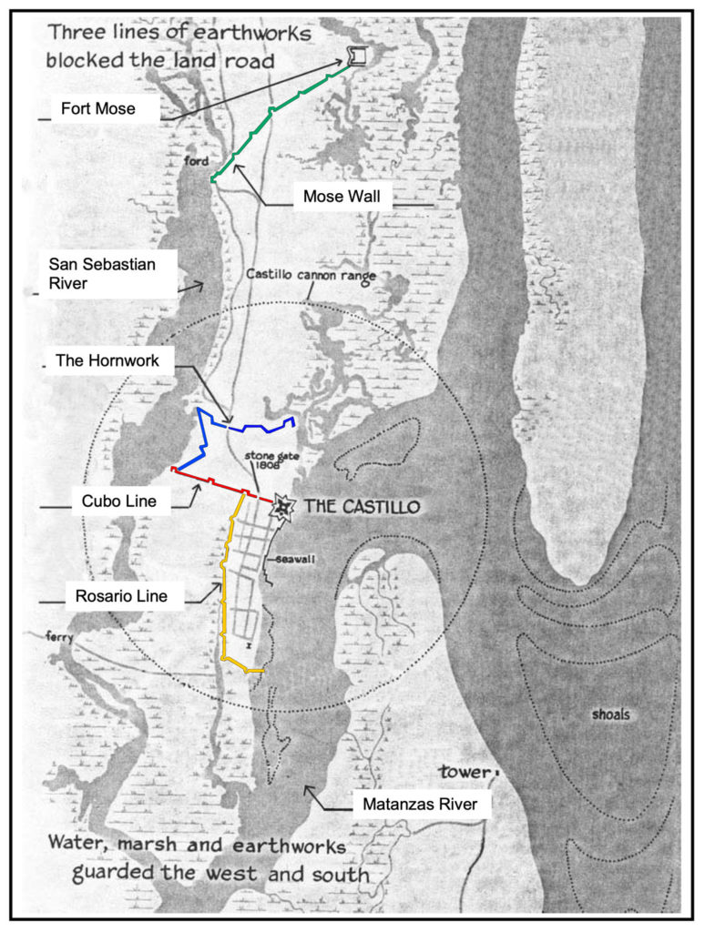
Running out from the western side of the Castillo, and reconstructed and visible today, is one of the city’s defensive walls. Like medieval cities, St. Augustine had not only a fortified stronghold but also a city gate and defensive walls. Most of these walls, or lines as the Spanish termed them, are reconstructions, though you will still feel very much like you’re walking through a medieval city when you see them (imagine, for example, the walls and gates of York, one of the most complete medieval walled cities in England.)
The gate and city walls of St. Augustine were not actually erected at its first settlement but in response to the British invasion of 1702. That experience prompted the city to enclose itself afterwards within medieval-style walls. The builders used native materials and constructed the lines as earthworks strengthened with local crushed coquina, or as walls of palm trunks.
St. Augustinians erected four protective lines: the Cubo Line (1704), the Hornabeque (or Hornwork) Line (1706), the Rosario Line (1718–19), and the Mose Wall (1762). [6] Each line also included redoubts (a term that comes from Classical Latin reducere “to lead back” and medieval Latin reductus “secret place” [7]), somewhat similar in concept to the turrets of the Roman-era Hadrian’s Wall in England.) You can visit a reconstructed redoubt, the Santo Domingo Redoubt, at the corner of Orange and Cordova Streets, near the VIC.
The lines of St. Augustine. Original image from NPS, overlaid by the author with colored lines.
Colonial historian Dr. Susan R. Parker describes the construction of the lines:
“Out from the Castillo’s west side went strong earthworks in the style of medieval European walled cities to protect against siege warfare. This wall surrounded the city’s three landward sides and became the physical limits of the colonial city.
[…] Years later, about 1762, the northernmost wall was added to connect with the village of Fort Mose, the settlement established for enslaved persons who escaped from English colonies to Spanish Florida.
The lines were built of soil with coquina sometimes incorporated for strength. To raise the height of the wall, Spanish bayonets and prickly cactus were planted along its top. The walls required endless repair. The biggest threat to the wall were the hooves of free-ranging cattle that pawed away at the berms.
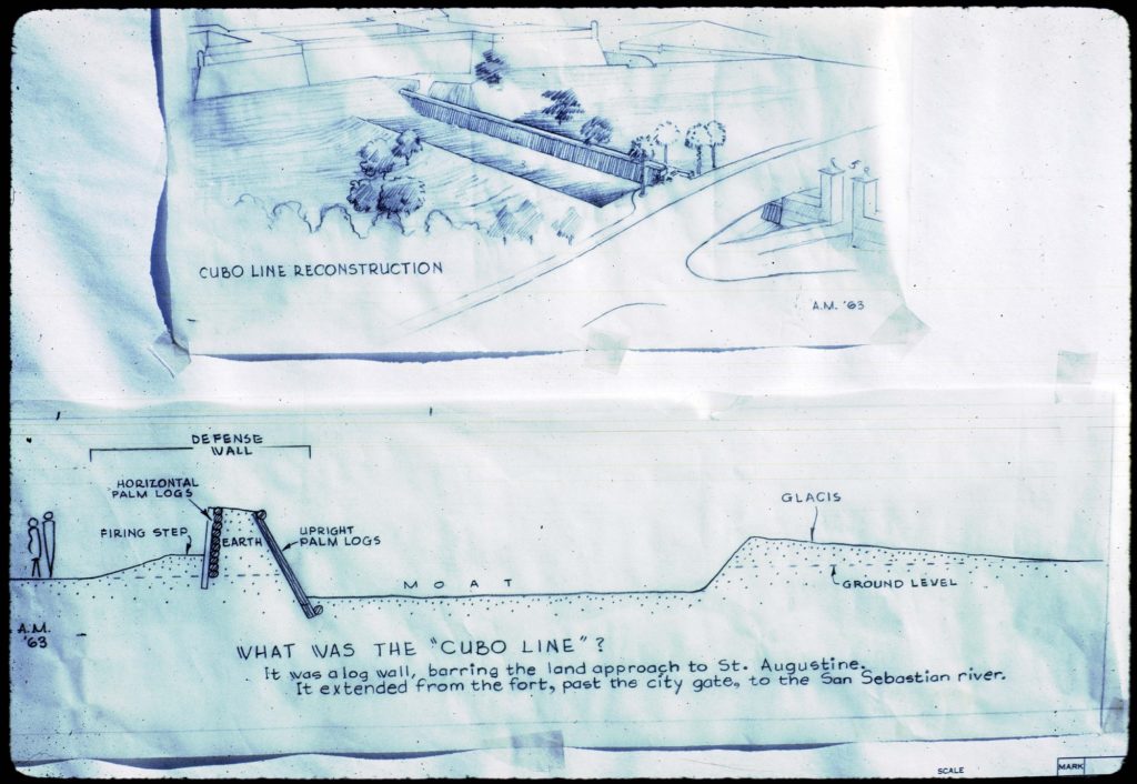
The reproduction Cubo Line that today crosses the grounds of the Castillo depicts a version of that barrier made of palm logs, built about 1808, a century after the first ‘Line.’ The City Gate was incorporated into this wall. The coquina pillars that stand today were built about the same time as the palm-log wall and replaced earlier entryways made of wood.” [8]
The Cubo line runs out of the west side of the fort, and the nineteenth-century version of palms was reconstructed in 1964 by the National Park Service. You can learn all about the materials and construction of this wall from NPS.
You can see more detail of the architecture of the Cubo line in the drawing below from the National Park Service.
Cubo Line Construction. Drawing by the National Park Service showing the proposed location of the replica town wall.
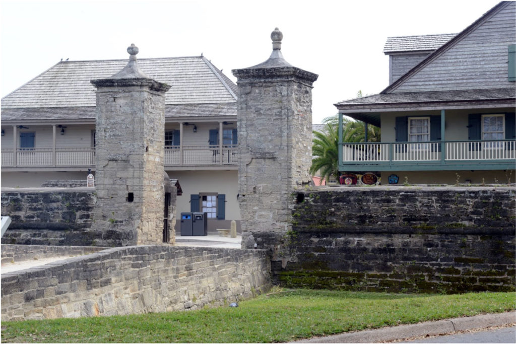
The city gates are part of the Cubo line and lie a short distance from the western fort wall. The existing gates were reconstructed in 1808.
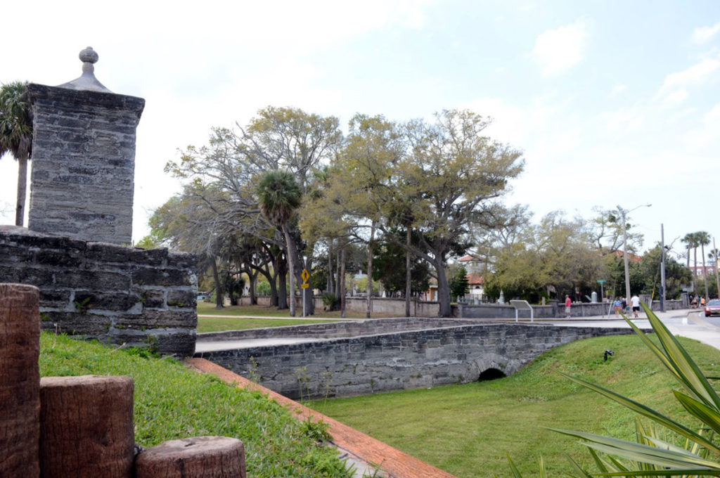
The reconstructed City Gates, seen from the north. The Cubo line runs on either side of the gate. St. George Street, the entrance into the walled town, runs through these gates. Photo by the author.Side view of the city gates, from the east, showing the defensive earthworks, entrance bridge of St. George Street, dry moat, and palms. Photo by the author.
The city lines were, in fact, what inspired me to write these blogs on the medieval roots of St. Augustine. Wandering around the old city on one visit a few years ago, I came across a part of the city wall, running between buildings on the northwestern edge and not particularly marked or noted in any way. I stood there for a bit, playing my fingers gently over the coquina and mortar, and thinking about the medieval city walls of York (themselves much reconstructed, like St. Augustine’s), and medieval flint church walls I’d just spent a year examining in the eastern U.K.
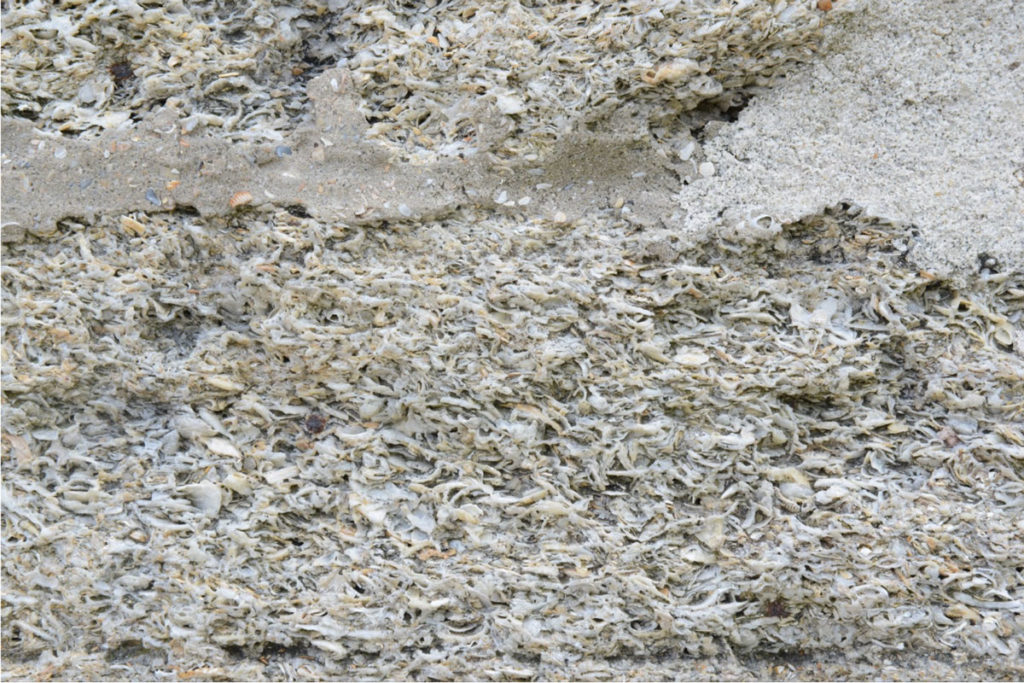
These sudden medieval encounters in the everyday world are striking, connecting us with the past physically, and showing us links with our natural environment and its long history of inspiring the construction of protective barriers, homes, and places of worship. Builders in the U.K. from the Romans to the Elizabethans relied on flint, a stone arising from the Chalk Escarpment of eastern coastal (and some of inland) Britain. The masons who made York’s medieval stone walls quarried their materials from the Magnesian Limestone formation in that area. The masons of St. Augustine drew on the native coquina, a limestone formed naturally of compressed and partially-dissolved shells of the coquina clam donax variabilis. St. Augustine’s limestone was quarried from nearby Anastasia Island.
Mortared coquina. The signature features of coquina rock—compressed shells of donax variabilis and their partially dissolved limestone—are visible here. Photo by the author.
The Historic City
While only a few reconstructed sections of the lines exist today, you can still enter the historic district of St. Augustine through its city gates, and from there step into a colonial Spanish town. Most of the city’s historic buildings are restored or reconstructed from its colonial era (First Spanish Period, 1565–1763; British Period, 1763–83; Second Spanish Period, 1783–1821) and early American period (after 1821). This lack of surviving older structures has much to do with St. Augustine’s military past: as a key outpost, the city weathered a number of massive attacks on its fort and settlement, such as Drake’s destruction of it in 1585 or the 1702 British attack that left the city burned to the ground again. Both post-Civil War Reconstruction and Henry Flagler’s investment and overhaul of the city in the late-nineteenth century meant the demolishing of many of the older buildings and construction of new ones.
The 1971 Historic St. Augustine Preservation Board’s Guidebook notes of the period of demolishment that “The old and storied inevitably gave way to the then new and modern. Many old houses and the remaining sections of the defense lines were uprooted to make way for new buildings. In those days these changes were hailed as a great improvement. Construction wasn’t the only enemy St. Augustine had, however; fire did its share of damage. In 1887 flames swept the Cathedral and much of the north block of the plaza. In 1914 a disastrous fire wiped out many of the buildings in the older section of the city between the city gates and the plaza.” [9] In the 1930s, though, St. Augustine became the focus of historic restoration, with organizing efforts to protect the historic district and return the city to its first Spanish period appearance. This Guidebook contains fascinating information from its time about the history and reconstruction of many of the buildings you can visit today.
Careful attention to the historical restoration process has resulted in a city that still reflects clearly its Spanish heritage. Albert Manucy in his book Sixteenth-Century St. Augustine writes,
“Although none of the first colonial houses of St. Augustine remain, it is clear from the later survivors that they are related to the folk architecture of northern Spain, the home of Pedro Menéndez, the town’s founder. Today in Oviedo and Santander Provinces one can see masonry houses, often with overhead balconies, front the streets. House lots are fenced to serve as corrals and stables. And in the town of Treceño there are houses with roomy ground-floor loggias, open to the yard through an arcade of two or three arches. These same styles can be seen in St. Augustine, and they have been there a long time.” [10]
This “folk architecture” itself was influenced by the medieval era (unfortunately I don’t have space to delve into this topic here.)
You can still see the city’s beginnings, though, in its layout and street plan, which has changed very little from its first formal layout in 1597. When Menendez and his group landed in the area in 1565, they first settled in cacique Seloy’s Timucuan village (the present-day Fountain of Youth Archaeological Park). After 9 months Menéndez and the settlers moved to Anastasia Island, then in 1572 moved back across the bay to the present site of St. Augustine and laid out their town. This town reflects a key feature of Classical and medieval architecture and a hallmark of Spanish urban planning: a plaza (though nascent) on the northern end of the town. To see what that town looked like, let’s step back Boazio’s 1589 map.
Close-up view of the earliest settlement of “wooden houses” with their “most pleasant gardens,” from the Boazio map of St. Augustine. The church is depicted with the letter “O,” at the northeast corner of the town (current-day corner of King and Aviles Streets). “M” is the “town house” and “N” is the watchtower. Image from the Library of Congress.
The legend for the map describes the fourteen-year-old settlement in this way:
“Opidum S. Augustini ligneis aedibus constructum, amoenissimos habuit hortos, utique solo faecundissimo”
(The town of St. Augustine, built of wooden houses, had most pleasant gardens, of course on a most fertile soil”).
Boazio’s engraving, showing Drake’s attack on the town, shows these houses and gardens, laid out to the south of the sixteenth-century fort.
Croftes describes the scene further, as the troop moved from the coast up the river:
“we might discerne on the other side of the river over against us, a fort [San Juan], which newly had bene built by the Spaniards, and some mile or there about above the fort, was a litle town or village without walls, built of wooden houses, as this Plot [Boazio’s map] here doth plainlie shew.” [11]
Boazio’s map shows a number of buildings, likely with palm- or palmetto-thatched roofs, and well-laid-out gardens. Archeological excavations have also confirmed the presence of a church, Nuestra Senora de Los Remedios (Our Lady of Remedies), since 1572 (St. Augustine, in fact, was America’s first Catholic parish). Records have confirmed the presence of a governor’s house near the water.
The open area surrounded by the church, town hall, and watchtower form a rough sort of early plaza, a plaza that was formalized shortly after by the next governor and that still exists today as the Plaza de la Constitucion, in the middle of the colonial halves of the city.
In their book, Ancient Origins of the Mexican Plaza, Logan Wagner, Hal Box, and Susan Kline Morehead discuss the importance of a central gathering place in city planning the world over, from ancient times to present. They note that “Plazas, or communal open spaces of some kind, have been at the core of every town and city in every culture on every continent.” [12] In the Western European world, the Greeks and Romans engaged in urban planning practices that provided for both sacred space (the Parthenon and Acropolis for Greeks, the Forum and Templum for Romans) and commercial and civic space (the market square).
About the development of urban planning in the Spanish New World, Wagner et al. write,
“The origins of Spanish urban layouts in the New World can perhaps be traced to urban design principles established by the celebrated Roman architect Vitruvius in the first century BCE; or possibly to ideas being discussed by the urban designers of the Italian Renaissance, especially Alberti; or even to the French bastides of the thirteenth century; or to the need to have a town layout that was expedient for military actions. The official policy of the Spanish Crown to design new towns in a grid or ‘checkerboard square’ pattern emanating from a central open space or plaza did not become official until well into the latter quarter of the first century of Spanish colonization, when grid layouts were finally made official in 1573 during the reign of Phillip II. The document in which these instructions were decreed is known as ‘The Laws of the Indies.’”
The authors note that, though the Laws were explicit and highly prescribed, in reality, settlements typically accommodated both existing native settlements and topographic features. [13]
When the Spanish settlers returned after Drake and his company ended their raiding and headed north to Virginia, they had to rebuild, and put up a new wooden fort as well. Carmelite lay brother Andrés de San Miguel described the refounded settlement in 1595 as being a little over a mile long (“one-half league”), with plenty of water to drink and various crops. Of the buildings he writes, “All of the walls of the houses are of wood and the roofs of palm and the more important ones of plank. The fortress [is] made of wood backed by a rampart.” Further, “The Spaniards make the walls of their houses out of this wood of cypress (sauino) because the part of it that is in the ground does not rot.” [14] The town that Fray Andrés saw was that depicted in a map of ca. 1593, the “de Mestas map,” possibly created by Hernando de Mestas, St. Augustine emissary to Spain.
When the new governor of La Florida, Gonzalo Méndez de Canzo, arrived to St. Augustine in 1597, he carried out Phillip II’s new Laws of the Indies and overhauled the layout of the city to that effect, including establishing a marketplace in the plaza. He also moved the governor’s house westward, to the back of the plaza, “probably to have the location of the governor’s office comply with Spanish ordinances that major buildings face the main square (plaza).” [15] The Laws of the Indies blended Classical and medieval urban planning traditions with early modern sensibilities and responded to both the practical requirements of Spanish colonial outposts and the desire for a fresh, new, planned aesthetic for a new age and a New World.
Méndez de Canzo’s layout for St. Augustine was the one that stuck for the city. Though the town was severely damaged in 1599, first by a fire that burned down the Franciscan monastery at the south end of town, and then by a hurricane that swept away most of the houses and killed many inhabitants, and burned down by the British in 1702, St. Augustinians kept rebuilding on the town layout. [16]
A 1711 map shows the new growth of the town, with the settlement and fort still somewhat distant from each other.
Map of St. Augustine, part of a larger map of Florida and the Carolinas, published about 1711 by Edward Crisp. Image from the Library of Congress.
By the time the British took over St. Augustine as part of the 1763 Treaty of Paris, though, the town had expanded northward and reached the area of the castillo. (From 1763-1783 Saint Augustine was a British territory, East Florida, and was its capital. In 1783 Britain gave this territory back to Spain, and in 1819 Spain gave it to the United States. )
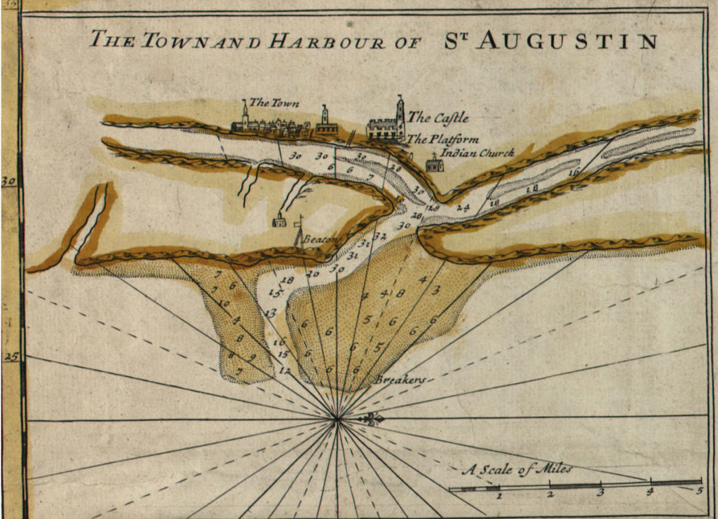
This 1855 view from the harbor shows how well-developed the plaza had become since Mendez laid it out in 1597.
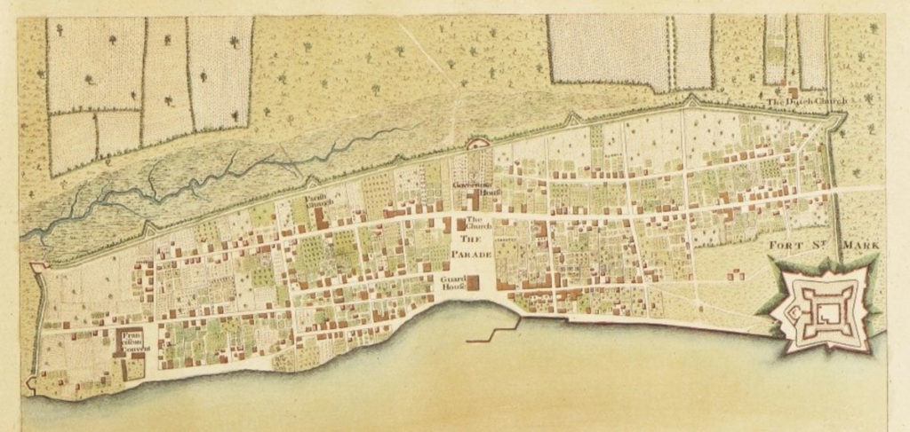
“Plan of the Town of St. Augustine, the Capital of East Florida,” by Thomas Jeffrys, published in William Faden, North American Atlas (1777). The map appeared first under a different title in William Stork, Description of East Florida (1769). Image from Boston Rare Maps Sale Catalogue.
Thomas Jeffrys’s 1769 map (above) shows that by the mid-eighteenth century, St. Augustine had grown to join with the fort, fully achieving de Canzo’s sixteenth-century plan. The Lines encompass the town, with the plaza (here formally noted as “The Parade”) at the center. This plaza was bounded by the Guard House at the harbor to the east, the church at the southwest corner, and the Governor’s House at the west end. The houses still had the “pleasant gardens” and orchards of the settlement’s earlier days. The fort appears at the northeast corner, with the Lines and their redoubts marked. The City Gate appears directly to the west of the fort, with present-day St. George Street running through the gates’ entrance into the walled city.
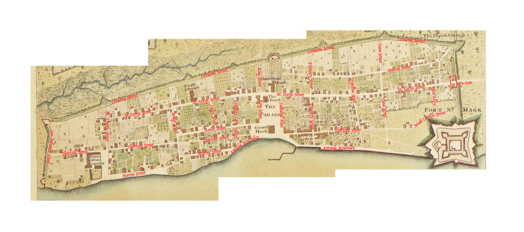
In the overlay I’ve done below, you can see how precisely the modern historic district maps onto Jeffrys’s eighteenth-centrury engraving of the town:
The Jeffrys map, with overlay in red by the author.
Remarkably, between this 1769 map and one of today, only a few of the streets have been swallowed up by development.
Walking through the streets of historic St. Augustine today is a treat for any lover of history. The careful reconstruction, street cobbles, balconies, and low buildings all create an atmosphere that is both medieval, European, and also distinctly Floridian. To see photos of more of the colonial buildings, check out this site.
The city claims to have currently “thirty-six buildings of colonial origin and another forty that are reconstructed models of colonial buildings.” Why not take a break from Disney World and visit something of Florida’s medieval history instead? You won’t regret it.
[1] Albert Manucy, Sixteenth-Century St. Augustine: The People and Their Homes (Gainesville: U P of Florida, 1997), pg. 36.
[2] It was first published in Latin and French in 1588 and then in English in 1589 (in two different editions) as A Summarie and True Discourse of Sir Frances Drakes West Indian Voyage (S.T.C. 3056 and 3057). Side note for lovers of book history: the second English edition of 1589 directs readers where to insert the maps, sold separately, into their copy of the book, and each of the four town maps has additional “textual keys, separately printed on broadside sheets intended to be cut and pasted at the bottoms of the four town maps.”
Mary Frear Keeler notes of the text and maps that “Richard Hakluyt reprinted the Summarie in his Principal Navigations, 3 vols. (London, 1598–1600); 12 vols. (Glasgow, 1903–1905). The engraved maps, printed with texts in three languages to correspond with the editions of the Summarie, are clearly associated with the publication of that narrative, and are referred to on the title page of the Ward edition (1589). A complete set of the Boazio maps is bound with the British Library’s copy of the Summarie (Field edition), numbered G. 6509” (“The Boazio Maps of 1585–86,” Terrae Incognitae 10 (1978): 71–80, at pg. 71).
[3] Croftes, A svmmarie and trve discovrse of Sir Frances Drakes West Indian voyage (London, 1589), p. 32.
[12] Logan Wagner et al., Ancient Origins of the Mexican Plaza: From Primordial Sea to Public Place (Austin: U of Texas P, 2013), pg.41.
[13] Wagner et al, pg.46.
[14] Fray Andrés de San Miguel, An Early Florida Adventure Story, trans. John H. Hann (Gainesville: U P of Florida, 2000), pp.76-7.
[15] Susan Richbourg Parker, “St. Augustine in the Seventeenth-Century: Capital of La Florida,” The Florida Historical Quarterly 92.3 (2014): 554–76, pg.556.
[16] Parker, “St. Augustine in the Seventeenth-Century,” pg.557.
Along oyster beds, sand dunes, and marshy coastal lowlands rise the church spires and walls of a medieval coastal city. This isn’t Northumbria’s Holy Island or Normandy’s Mont-St-Michel, though. This is the City of St. Augustine, Florida, the oldest city continuously occupied by Europeans and African-Americans in North America. This settlement on Florida’s First Coast predates the arrival of the Mayflower pilgrims at Plymouth in 1620 and even the 1607 founding of Jamestown, the first permanent English settlement.
The Age of Reconnaissance
St. Augustine was founded by the Spanish in 1565 as part of the fifteenth- and sixteenth-century European push to discover, explore, and settle new lands beyond Europe. This “Age of Reconnaissance” is one of the hallmarks for historians of the transition from the late Middle Ages into the Early Modern period in Europe.
Historian J. H. Parry describes the medieval beginnings of this push, especially in Spain:
“The initial steps in expansion were modest indeed: the rash seizure by a Portuguese force of a fortress in Morocco; the tentative extension of fishing and, a little later, trading, along the Atlantic coast of North Africa; the prosaic settlement by vine and sugar cultivators, by log-cutters and sheep-farmers, of certain islands in the eastern Atlantic. There was little, in these early- and mid-fifteenth-century ventures, to suggest world-wide expansion.”
In the later fifteenth-century, though, this expansion indeed exploded globally. [1] The desire to expand wealth through acquisition of new lands, slave labor, and precious metals and stones, as well as the desire to convert any newly-discovered peoples to Catholicism, were powerful enticements for Spain to explore. Developments in nautical navigation, map-making, and ship technology made exploration possible.
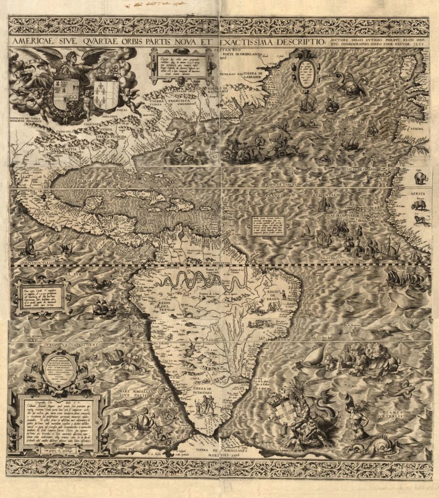
“Americae sive qvartae orbis partis nova et exactissima descriptio” (“A new and most exact plan of America, or the fourth part of the world”), created by Diego Gutiérrez and Hieronymus Cock in 1562. Library of Congress Geography and Map Division Washington, D.C. 20540-4650 USA dcu.
Spain’s first encounter with the Florida coast came during the explorations of a medieval Spaniard, Juan Ponce de Léon (b. ca. 1460 in Léon, Spain). In early April 1513, with a license from Spain’s King Ferdinand II (1452–1516), Ponce de Léon sailed from Puerto Rico looking for Bimini (the Bahamas) and, legend has it, the Fountain of Youth. He found Florida instead, landing somewhere between St. Augustine and Melbourne Beach.
Claiming it for Spain, he gave the supposed island its Spanish name of La Florida, or Pascua Florida, depending on which source you look at; both names suggest Ponce de Léon was struck by the abundance of flowers he must have seen. (“Pascua Florida Day” is a state holiday and is celebrated on or around April 2nd each year.) He then sailed southward around the peninsula to explore further. [2] Ponce de Léon returned to Spain and procured Spain’s consent to colonize the New World; thus Spanish settlement began. [3]
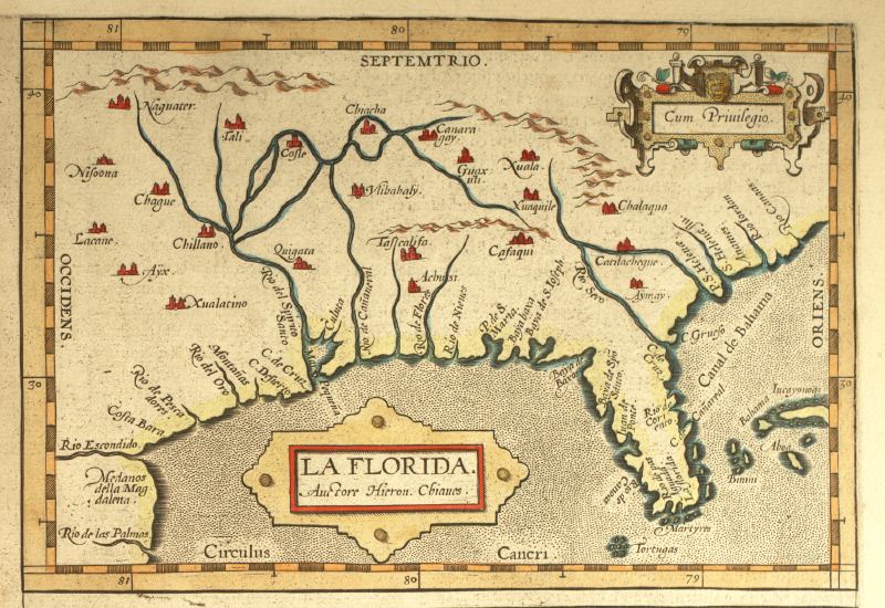
“La Florida,” printed in Geronimo Chaves, Theatrum orbis terrarum (Antwerp: Abraham Ortelius, 1584). Special Collections Department, University of South Florida.
The Settlement of St. Augustine
Fifty-two years later, with a new French settlement threatening Spain’s claim to this territory, King Philip II commissioned Spanish admiral Pedro Menéndez de Avilés to colonize the area and remove the French. On August 28, 1565, the feast of St. Augustine, Menéndez, his crew, soldiers, and settler families, over 2,000 souls traveling in 11 ships, sighted this land from sea and named it after the saint.
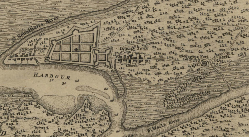
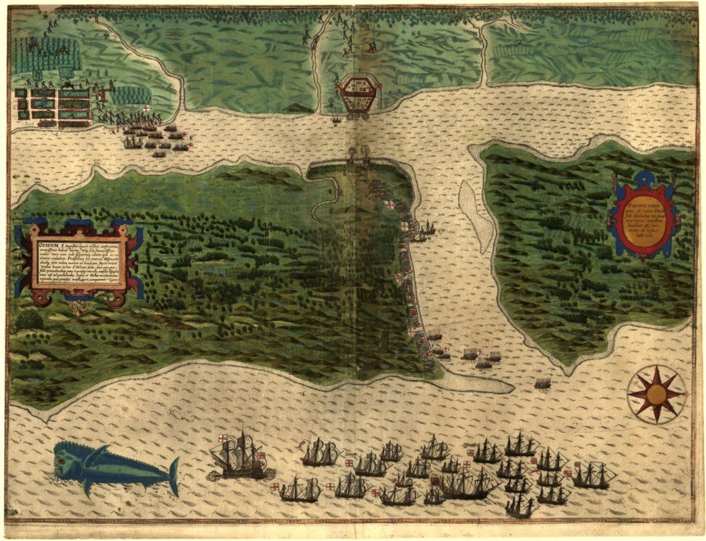
Menéndez and the settlers built defenses (pictured below, top center, which St. Augustinians replaced a little over a hundred years later with a stone fort, the Castillo de San Marcos) and laid out homes and plots for cultivation (pictured below, top left). St. Augustine was thus established and remained a hub of Spanish Florida, both for military defense and as a home base for Catholic missionaries.
Map of St. Augustine, created in 1589 by Baptista Boazio. Oriented with north to the right. The Castillo de San Marcos is pictured at top center. Held in the Hans and Hanni Kraus Sir Francis Drake Collection (Library of Congress, Geography and Map Division).
Sadly, the next 50 years saw the Spanish settlers nearly annihilate the native Timucuan peoples of the area through disease and war. [4] The Spanish did aid escaped slaves, though, albeit conditionally. As early as 1687, Blacks escaping slavery in the nearby British colonies of Georgia and the Carolinas sought asylum in St. Augustine, the second-largest town in the southern colonies. [5] They received freedom in exchange for converting to Catholicism and, for men, joining the Spanish military. (In 1738 this settlement became a fortified town, Gracia Real de Santa Teresa de Mose, the first free Black community in the colonies, at the north end of St. Augustine. The settlement is now commemorated as Fort Mose Historic State Park.) [6]
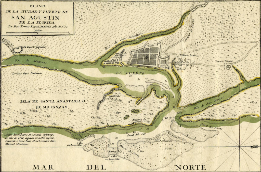
“Plano de la ciudad y puerto de San Agustin de la Florida” (Map of the City and Port of St. Augustine, Florida”), created in 1783 by Tomás López de Vargas Machuca. Held in Library of Congress Geography and Map Division Washington, D.C. 20540-4650 USA dcu. The Castillo de San Marcos and town plan to the west are pictured top, slightly right of center. Fort Mose is north of the Castillo de San Marco and labeled as “Fuerte Negro” (Black Fort).
St. Augustine’s Coat of Arms
The later settlers of St. Augustine remained close to their medieval and colonial Spanish roots. In 1715, in fact, the city residents petitioned King Philip V of Spain for a coat of arms of their own, to reflect that heritage (they had previously used a version of the coat of arms of Castile and León, which appears on a lintel in the Castillo de San Marcos). They wrote to the king “to grant to them for arms, a ‘flor de lis, lion, castle and strong arm with cross in the middle’ and the title ‘Most Loyal and Valorous’ for their faithful and courageous service to Spain.” [7]
Philip did indeed grant the request, but neither the news nor the design of the coat of arms reached the city. In 1911 the City renewed its request with Juan Carlos I, King of Spain. Vicente de Cardenas y Vicent, Herald, King of Arms, Dean of the Corps of Heralds for Spain, informed St. Augustinians that indeed, the Coat of Arms had been granted on November 26, 1715, along with the title of “Most Loyal and Valorous” city. [8]
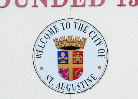
Photo by the author, Dr. Megan Hall (2022).
St. Augustine’s coat of arms contains the requested elements displayed on a shield, all topped by a crown. The seal and its elements draw on the medieval tradition of heraldry, which developed in Europe in the eleventh century as a way to visually distinguish and identify armor-covered knights on a battlefield. [9] In the next century heraldry grew to encompass family identity and then shortly after corporate identity, such as for monasteries, universities, and towns. [10]
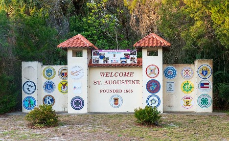
Welcome Gateway in St. Augustine, Florida. Photo by the author, Dr. Megan Hall (2022).
St. Augustine’s seal visually marks the city’s medieval history and Spanish heritage as well as its city-hood (signified by the crown above the shield). In particular, the shape of the coat of arms’s shield is medieval and its golden cross signals the city’s Christian origins; the golden castle of Castile and the purple lion of León call back to the city’s Spanish heritage. St. Augustine proudly employs this coat of arms and crown on their city seal today, at a gateway that greets visitors to the city.
Join me later this summer for the second part of this series, when we’ll take a deeper dive into the medieval heritage of the city that you can still enjoy today!
About the Author
Dr. Hall earned her Ph.D. in Medieval English Literature from the University of Notre Dame and her M.A. and B.A. in English Literature from the University of Georgia. She has authored a number of publications including essays in Journal of the Early Book Society, Early Middle English, and History of Education Quarterly. She is also a native Floridian who enjoys defending her claim that Florida has a medieval past. She’s written about her home state’s early history since her first historical fiction novella, Gold Coast (1997), about the Spanish exploration of Florida.


