Reading the Medieval Landscape through Archaeological Maps of the Nineteenth and Early Twentieth Centuries

There are few things I like to do more than pouring over an old map.  For those working on the Maeander River Valley (modern Büyük Menderes in western Türkiye), we are spoiled by old maps from archaeological surveys and excavations from the nineteenth and early twentieth centuries.  Unlike earlier maps, these maps surveyed and composed for archaeological purposes were more detailed and often more accurate in their spatial representation.  In this blog, I want to introduce two fascinating maps.

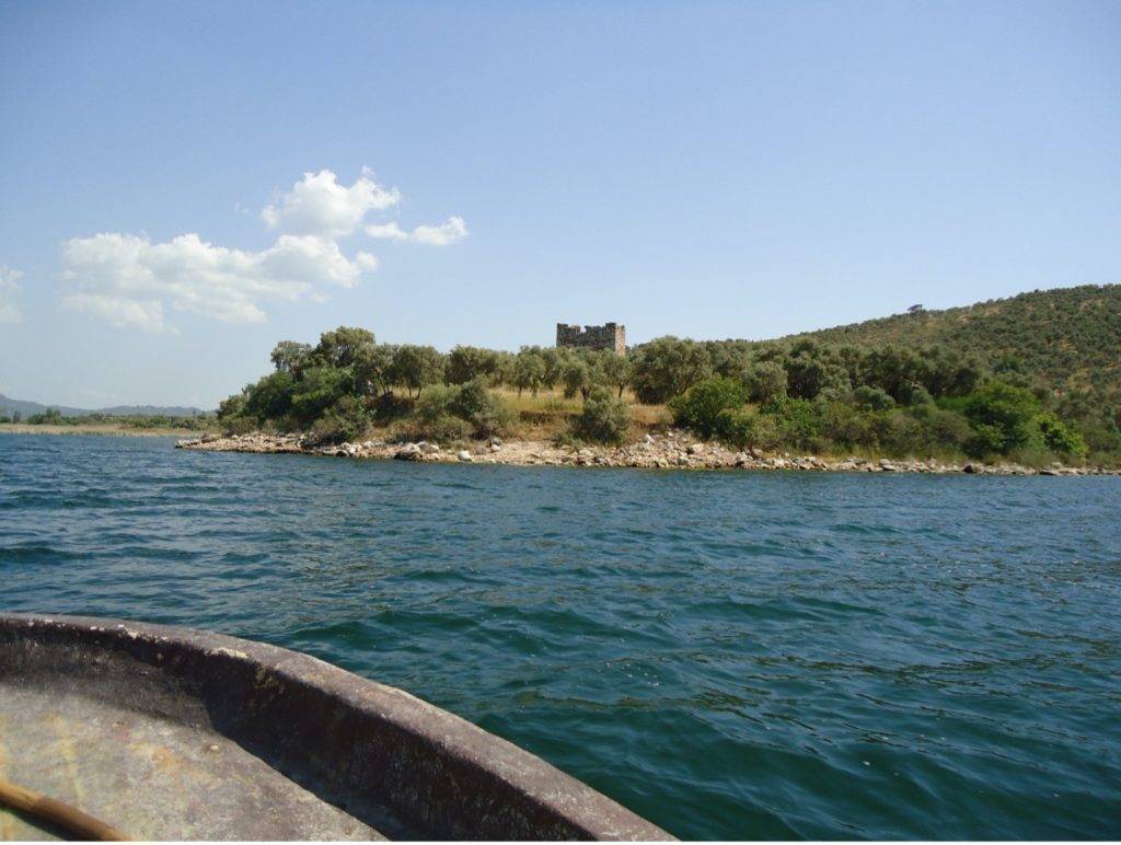
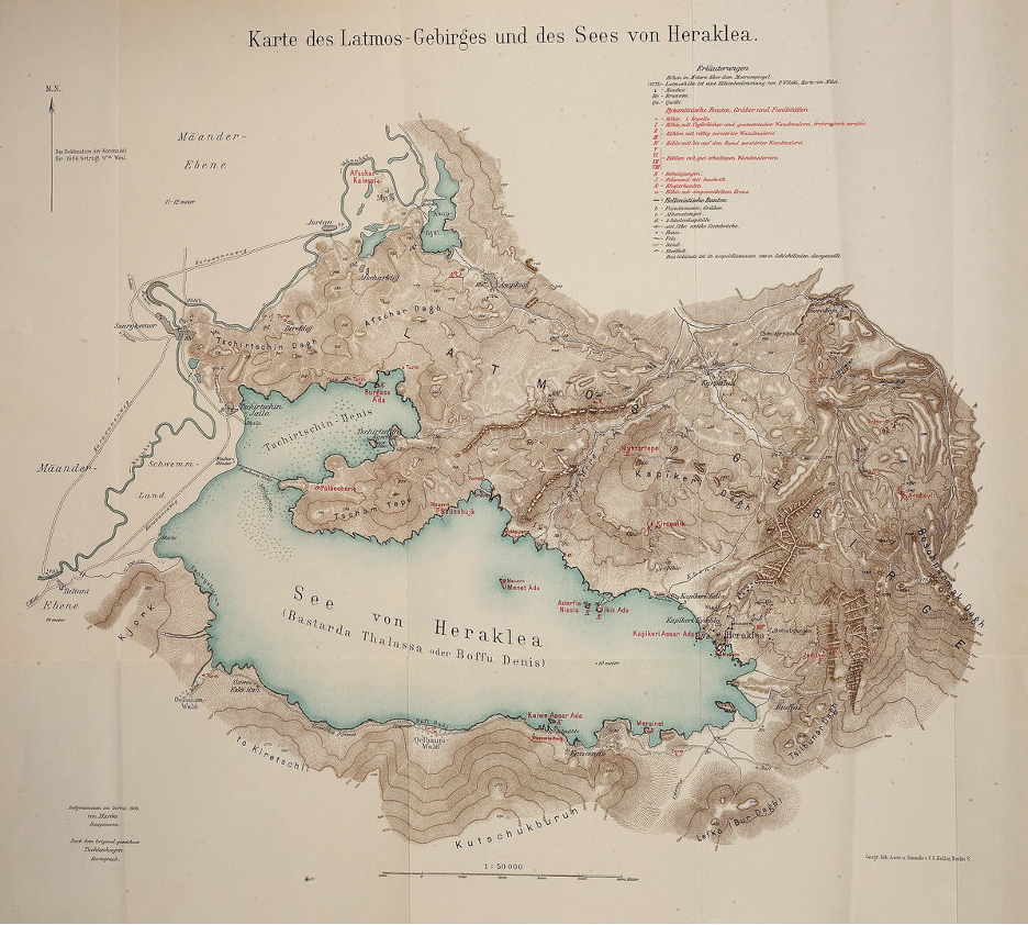
First, is the Lyncker map, named for the military officer Karl Lyncker who carried out the bulk of the investigations around 1908 and 1909.  The map was produced for the archaeological exploration and excavations conducted in the valley by Theodor Wiegand.  This map is best understood as a composite map, including the map of Lake Bafa by the military officer Walther von Marées in 1906 (Fig. 1) and the map of the Milesian peninsula by the mine surveyor Paul Wilski in 1900 (Fig. 2).  Alfred Philippson, a geologist, would conduct his own surveys and produce his own map in 1910 (Fig. 3).  Later, Philippson would compile all the earlier maps and publish them as a composite map in 1936 in the series of volumes of the Miletus excavation.[1] 

Figure 1: A Map of Mount Latmos and Lake Bafa produced by Walther von Marées in 1906.
Figure 2: A Map of the Milesian Peninsula produced by Paul Wilski in 1900. 
Figure 3: A Map of Western Asia Minor produced by Alfred Philippson in 1910.

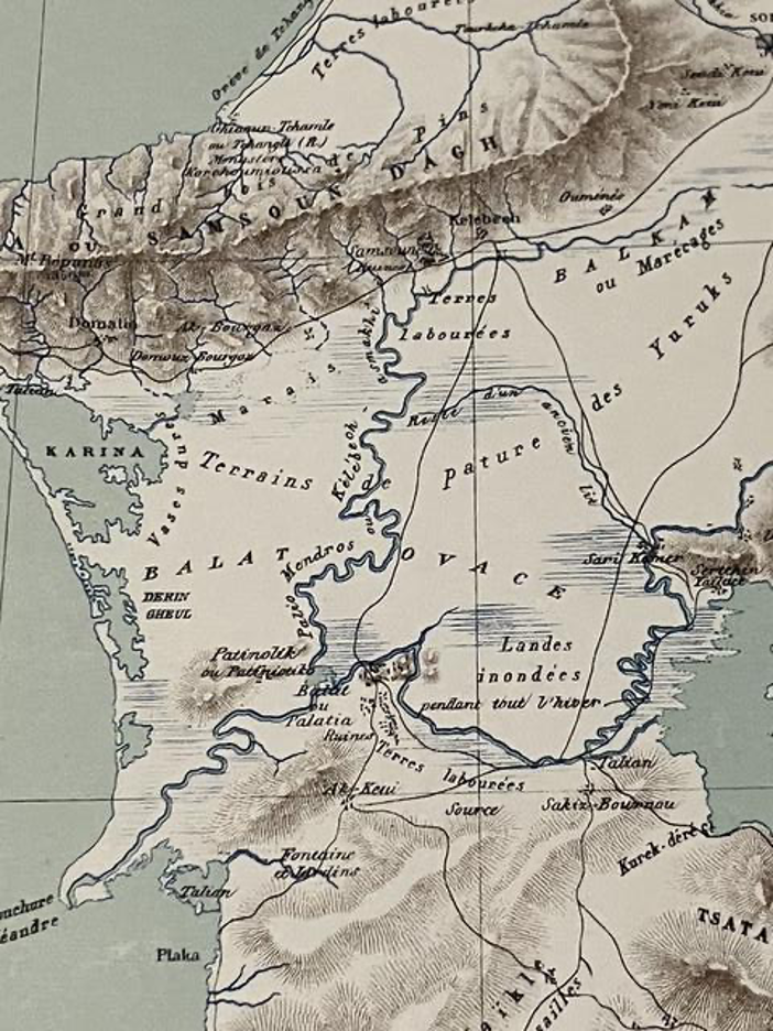
The second map accompanied the archeological work of Olivier Rayet and Albert Thomas and was composed in 1874 (Figs. 4, 5, and 6).[2]  While Wiegand outsourced his cartography to professional geodesists, Rayet drew the map himself.

Figure 4: A Map of the Maeander River Valley produced by Olivier Rayet in 1874.
Figure 5: Close Up of the Area Around Miletus (Balat ou Palatia) in the Rayet Map.
Figure 6: Close Up of the Area Around the Turkish Town of Söke (Sokhia) in the Rayet Map.

These maps are an important source of ancient and medieval ruins that have since disappeared.  However, I have always marveled at what these maps reveal unintentionally:  the landscape of the late Ottoman Maeander Valley before a series of changes that would occur in the twentieth century.

Before the Population Exchange of 1923

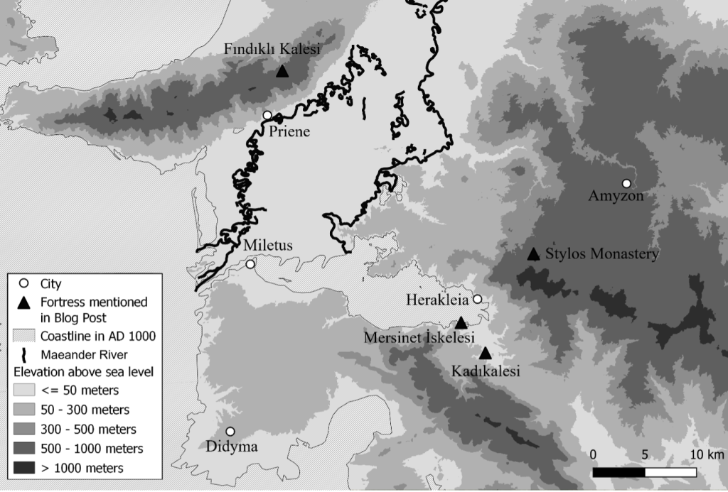
In 1923, the Greek populations living the Maeander were exchanged with Turkish populations living in Greece.  These maps include many Greek toponyms that are no longer used.  Didyma is known by its Byzantine name of Hieron (Jeronda), while the town on the southern coast of Lake Bafa was known as Mersinet, a survival of the Byzantine Myrsinos (Fig. 1).  The toponym of Patniolik (Figs. 2, 3, and 5), which became the modern Batmaz Tepe (the hill that cannot sink), makes clear that the origin is not Turkish, but Byzantine; this was a village owned by the monastery of Saint John the Theologian on the island of Patmos.  On the southern face of Mount Mykale, the ancient site of Priene is still known by its Byzantine name of Samson (Samsoun) on the Rayet map (Fig. 5), while the village of Domatia (Figs. 3 and 5) is likely the survival of the Byzantine toponym Stomata, which references the mouth of the Maeander River. 

The town of Bağarasi (Gjaur – Bagharassi on the Lyncker map) missed out having its old Greek name, Mandica, as it was renamed after the Greek War of Independence (1829).  Still, not all Greek toponyms imply a direct Byzantine survival.  The Greek communities of the late Ottoman period are idiomatic to their time and are not simply the fossils of another era; some immigrated from the islands after the plagues of the seventeenth century, while others moved to the area to work for local Turkish lords (like the Cihanoğlu family in the Turkish town of Koçarlı – there is no reason to assume that the church in Koçarlı in the Lyncker map required a Byzantine predecessor). 

Before the Draining of the Büyük Menderes

Beginning in the late 1920’s, a series of drainage canals fundamentally transformed the hydrological realities of the Maeander Valley.  Before the construction of this system of canals, the Maeander valley flooded every winter and remained inundated until spring.  This could wreak havoc on transportation across the valley and rendered many places in the plain isolated throughout the winter.  A rather frustrated Gertrude Bell – a Byzantinist in her own right – who visited the Maeander Valley around the same time as Lyncker, remarked:

“This sort of travelling is far more difficult and less pleasant than my Syrian journeys.  There one simply gets onto a horse and rides off, carrying one’s house with one.  Here there are so many arrangements to be made and one has to depend on other people’s hospitality which is always a bore.  It’s worth doing however and while I am about it, I will see as much of the country as I can so that I need not come back.”[3]

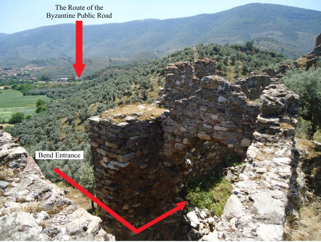
The draining of the valley was not just the construction of individual canals, but the construction of a system of canals that included the entire valley, where the canals, parallel to the river, provided drainage for the entire valley.  Greeks, Romans, Byzantines, and Ottomans all had drainage of some type in the Maeander, but I have seen no evidence of a valley-wide attempt to drain until the early years of the Turkish Republic.[4]  One of the clearest representation of these canals as a system is found in a map from a British Naval Intelligence Division geographical handbook from 1943, when this process was well underway but far from finished.[5] 

Despite the difficulties of living in the open plain in this period, the Lyncker map shows considerable number of settlements, from the series of houses along the river between Priene and Miletus, to the villages east of the town of Söke (Fig. 3).  While the Rayet map is less detailed in showing the late Ottoman settlement pattern, it does often show where the major fields were located (Terres labourées), such as the northeastern extreme of the Milesian peninsula, those directly south of Priene (Fig. 5), and the plain between Söke and Burunköy (Bouroun Keui, Fig. 6).  Because marshes are dynamic and seasonal in the Maeander, that these two maps do not show the same regions as swamp makes sense.  The Lyncker map is oriented more towards the summer and fall, mapping the lakes found at the center of a swamp, while Rayet shows the much wider area that likely saw itself underwater during the winter and spring.  Near Miletus (Balat ou Palatia), Rayet designates “lands flooded during the winter” (Landes inondées pendant tout l’hiber).  In fact, this is a consistent problem when examining maps, even into the second half of the twentieth century.  What can appear as an invented lake – a “paper lake,” if you will – is instead a cartographer mistaking what is permanent for what is seasonal.

For western Türkiye, the twentieth century introduced a series of fundamental changes to the landscape.  Being able to see what the landscape looked like before that can provide important insights about the medieval landscape.  But, if I am honest, pouring over these maps is simply just a great way to pass an afternoon!

Tyler Wolford, PhD
Byzantine Studies Postdoctoral Fellowship
Medieval Institute
University of Notre Dame


[1] Alfred Philippson.  Das südliche Jonien.  Milet III.5.  Berlin and Leipzig, 1936.

[2] Olivier Rayet and Albert Thomas. Milet et le Golfe Latmique, Tralles, Magnésie du Méandre, Priène, Milet, Didymes, Héraclée du Latmos: Fouilles et explorations archéologiques.  Paris, 1877.  This map can be viewed online at http://digi.ub.uni-heidelberg.de/diglit/rayet1877a/0002.

[3] https://gertrudebell.ncl.ac.uk/l/gb-1-1-1-1-17-19

[4] Süha Göney. Büyük Menderes Bölgesi. Istanbul, 1975, 245-256.

[5] Naval Intelligence Division.  Turkey.  Volume II.  Geographical Handbook Series.  1943, 159.

Why Fortify?  A Short Introduction to Four Byzantine Fortifications in the Maeander Valley

I chose these four fortresses as representations of the observable differences between Byzantine fortified sites.  Not all fortifications were made equal.  Differences lie not only in the choice of how walls and towers are constructed, but also in the placement of these fortified sites in the landscape.  Careful analysis of these features can reveal the underlying assumptions and motivations of the builders.  I have chosen among these four fortifications a military base, a refuge, a center for agricultural exploitation, and a fortified residence within the Maeander River valley.

The Locations of the Fortresses, made by author in QGIS.

Kadıkalesi[1]

Kadıkalesi is a great example of a military fortress likely built and used by the Byzantine armed forces.  The entrances, not just the main one but the two postern entrances too, had a bent gate, which denies an attacker a good view inside the fortress (see Figure 2).  The towers project from the walls and include a larger circular tower which is more resilient to projectiles than a square tower.  Throughout the entire circuit of walls, platforms known as battlements were built for soldiers to be able to view the landscape.  The walls were caped with crenulations, which provided coverage for those soldiers from fire from below (see Figure 3).  This fortress was found on a small hill above a road, about 50 meters above sea level.  On the one hand, this elevation gave the soldiers good visibility of the surrounding countryside, but, on the other, it was low enough that the soldiers could quickly do something about a threat (see Figure 2). 

The Bent Gate of Kadıkalesi, photo by author.
The Battlements of Kadıkalesi, photo by author.

Fındıklı Kalesi[2]

Fındıklı Kalesi was a large fortress on the top of a mountain, enclosing an area of seven hectares at an elevation higher than 600 meters above sea level.  Like Kadıkalesi, the walls were built with military concerns in mind; a series of towers and periodic battlements defend the portions of wall spanning the gaps between rocks, while a double gate fortifies the most vulnerable part of the fortress in the southeast.  The size of the fortress was partly determined by geology; the walls follow the edges of a massive rock outcropping.  Unlike Kadıkalesi, however, the fortress was isolated from the Byzantine roads that cross the mountain and unable to serve in the policing of routes.  I agree with scholars who see Fındıklı Kalesi as a refuge for times of invasion with only a small permanent peacetime population.[3]  This was a fortress, not of lords or soldiers, but of farmers and shepherds, who needed its great size to house flocks of sheep and its isolated location to keep just far enough away from any potential raiders that this ‘bluff in stone’ may appear like a formidable military fortress. 

View North from Inside Fındıklı Kalesi, photo by author.

Mersinet İskelesi[4]

The impressive fortress found on the southern coast of Lake Bafa appears to be a military fort like Kadıkalesi.  The use of blind arches to support the battlements even shows an improvement over the thick walls of Kadıkalesi.  However, I argue that military effectiveness was not the main concern of this fortress.  The defining element of the fortress is a great tower bisected by the enceinte wall.  However, there is no communication between the walls and the tower; anyone stationed in the tower could not advance into the battlements in response to a threat.  Second, the tower does not protrude from the wall, which decreased its visibility and potential range of fire.  While Mersinet İskelesi’s position does provide a good view of the eastern half of Lake Bafa, nearby hills could provide a better view.  Instead, this fortress has more in common with the isolated towers found around Lake Bafa and in the wider Maeander Valley.  Mersinet İskelesi is an isolated tower with an increased budget.  I suspect that this fortress and the other towers have something to do with the exploitation of agricultural estates as these towers lie at the edge of the most plentiful area of farmable land adjacent to Lake Bafa, even if this fortress is usually interpreted as a fortified monastery[5] or military base.[6] 

View of Tower of Mersinet İskelesi from Lake Bafa, photo by author.
Central Tower of Mersinet İskelesi from inside the Fortress, photo by author.

The Monastery of Stylos[7]

The final fortress is the monastery of Stylos.  Its walls aided the defense of a community which resided in isolated places like a type of fortified residence.  However, this monastery was never intended to operate like a military fortress.  For instance, the battlements were limited to walls located at known entrances on the north and south side.  They were only interested in watching visitors who intended to use a proper gate and not in observing the wider region.  Nor was it a refuge.  While the monastery was deep in its mountain like Fındıklı Kalesi, Stylos is near a branch of an ancient road network, which gives the monastery a greater ability to interact with others on and off the mountain.  Finally, the division of interior fortification betrays a uniquely monastic concern: the proper veneration of the founder of the monastery.  The inner bastion of the monastery contains the hermitage of Saint Paul the Younger cut in a tower of rock and decorated with a painted program of religious images (see Figures 6 and 7).  I suspect the fortification of the hermitage likely served to encourage the veneration of their founder and to connect that founder with the builder of the walls, likely Christodoulos of Latros who would go on to found the Monastery of Saint John the Theologian on Patmos.  Whatever the purpose of the inner gate was, it is hard to imagine it served the defense of the monastery. 

The Inner Gate of Stylos Leading to the Hermitage, photo by author.
View of the Hermitage of Saint Paul the Younger, photo by author.

Tyler Wolford, PhD
Byzantine Studies Postdoctoral Fellowship
Medieval Institute
University of Notre Dame


[1] Wolfgang Müller-Wiener, “Mittelalterliche Befestigungen im südlichen Jonien,” IstMitt 11 (1961): 19-23.

[2] Hans Lohmann et al., Survey in der Mykale 1, Bonn: Rudolf Habelt, 2014-2017, II.510-513 (MYK 65).

[3] Jesko Fildhuth, Das byzantinische Priene, Berlin: DAI, 2017, 96-98; for an opposing view see Lohmann et al., Survey in der Mykale, I.284-290.

[4] Müller-Wiener, “Mittelalterliche Befestigungen,” 17-19.

[5] Urs Peschlow, “Latmos,” Reallexikon zur byzantinischen Kunst 5 (1995): 695-696.  

[6] Müller-Wiener, “Mittelalterliche Befestigungen,” 18-19.

[7] Theodor Wiegand, Der Latmos, Milet III.1, Berlin: Georg Reimer, 1913, 61-72.